IMAGES TAKEN NEAR TO
JEDBURGH, TD8 6NR
Introduction
This page details the photographs taken nearby to TD8 6NR by members of the Geograph project.
The Geograph project started in 2005 with the aim of publishing, organising and preserving representative images for every square kilometre of Great Britain, Ireland and the Isle of Man.

There are currently over 7.5m images from over14,400 individuals and you can help contribute to the project by visiting https://www.geograph.org.uk
Image Map
Images are licensed for reuse under creativecommons.org/licenses/by-sa/2.0
Notes
- Clicking on the map will re-center to the selected point.
- The higher the marker number, the further away the image location is from the centre of the postcode.
Image Listing (27 Images Found)
Images are licensed for reuse under creativecommons.org/licenses/by-sa/2.0
Image
Details
Distance
1
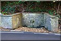
Indian Mutiny Memorial near Jedburgh
A memorial fountain or well by the A68 south of the town. Two local families lost relatives in the Indian Mutiny uprising in 1857, resulting in this memorial fountain by the roadside, dated 1857. The panel is inscribed
To the women and children who suffered in India during the Sepoy mutiny.
The fountain is known locally as the 'Dribbly Well'. (From the information panel on the west side of the road).
Image: © Jim Barton
Taken: 11 Oct 2020
0.06 miles
2
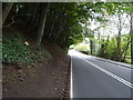
Newcastle Road (A68)
Heading south from Jedburgh.
Image: © JThomas
Taken: 11 Oct 2021
0.06 miles
3
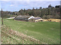
Mill building at Jedburgh
Noted on the Explorer Map as a mill and on the very edge of the square.
Image: © Walter Baxter
Taken: 18 Mar 2007
0.06 miles
4
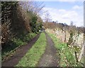
A road at Galahill, Jedburgh
Part of a heritage trail around the town of Jedburgh.
Image: © Walter Baxter
Taken: 18 Mar 2007
0.09 miles
5
A proliferation of walking routes
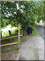
A sign on Galahill indicates a large number of waymarked walking routes based on Jedburgh, including the Border Abbeys Way.
Image: © Oliver Dixon
Taken: 21 Sep 2014
0.10 miles
6
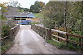
Bridge at Allar's Mill, Jedburgh
A bridge over the Jed Water giving access to the old mill buildings now used as a storage depot.
Image: © Jim Barton
Taken: 4 Oct 2011
0.10 miles
7
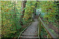
Steps near Allar's Mill, Jedburgh
A long flight of steps leads down from the lane used by the Borders Abbeys Way to the Jed Water, on one of the Jedburgh paths.
Image: © Jim Barton
Taken: 4 Oct 2011
0.11 miles
8
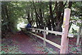
Steps down to the Miller's Burn, Jedburgh
On the route of the Borders Abbeys Way; the lane between Todlaw farm and here is a quagmire in places, ensuring authentically muddy boots for the walk into Jedburgh.
Image: © Jim Barton
Taken: 28 Oct 2011
0.11 miles
9
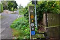
Waymarks in Jedburgh
Waymarks for the Borders Abbeys Way, Jedburgh Paths, Jedforest Trails, the Justice Trail (a 40km cycle route) and the Jedburgh Circular Riding Route (total length 22km).
Image: © Jim Barton
Taken: 11 Oct 2020
0.12 miles
10
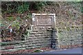
Plaque for the Blaikup Stone, Jedburgh
The plaque is on the E side of the A68, and reads:
Near this spot
the Blaikup Stone
formerly stood
I have not been able to find information about the Blaikup Stone or its history - it would be interesting to know more from those with local knowledge.
Image: © Jim Barton
Taken: 19 Dec 2013
0.13 miles