IMAGES TAKEN NEAR TO
JEDBURGH, TD8 6LS
Introduction
This page details the photographs taken nearby to TD8 6LS by members of the Geograph project.
The Geograph project started in 2005 with the aim of publishing, organising and preserving representative images for every square kilometre of Great Britain, Ireland and the Isle of Man.

There are currently over 7.5m images from over14,400 individuals and you can help contribute to the project by visiting https://www.geograph.org.uk
Image Map
Images are licensed for reuse under creativecommons.org/licenses/by-sa/2.0
Notes
- Clicking on the map will re-center to the selected point.
- The higher the marker number, the further away the image location is from the centre of the postcode.
Image Listing (6 Images Found)
Images are licensed for reuse under creativecommons.org/licenses/by-sa/2.0
Image
Details
Distance
1
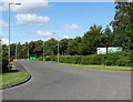
Entrance to Oxnam Industrial Estate
High above Jedburgh town on the east side.
Image: © Oliver Dixon
Taken: 2 Aug 2012
0.05 miles
2
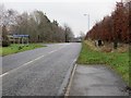
Oxnam Road leaving Jedburgh at Wildcat Gate
Looking south-eastward.
Image: © Peter Wood
Taken: 12 Dec 2018
0.07 miles
3
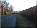
Heading out of Jedburgh
On the Oxnam road.
Image: © James Denham
Taken: 27 Jan 2011
0.07 miles
4

Rowan Road, Jedburgh
A rather stark modern housing estate off the Oxnam Road, high above Jedburgh town.
Image: © Oliver Dixon
Taken: 2 Aug 2012
0.09 miles
5

Hartrigge Industrial Estate, Jedburgh
This is the Mainetti UK Ltd factory at Oxnam Road viewed from a field near Tudhope in the adjacent square to the west.
Image: © Walter Baxter
Taken: 11 May 2011
0.18 miles
6

Factory silos above Jedburgh
Silos or storage tanks at the Mainetti factory, manufacturer of coat hangers and garment display products for the retail trade, here looming above the field like some medieval castle. See Image for another view.
Image: © Jim Barton
Taken: 18 Nov 2012
0.20 miles