IMAGES TAKEN NEAR TO
Honeyfield Road, JEDBURGH, TD8 6JW
Introduction
This page details the photographs taken nearby to Honeyfield Road, TD8 6JW by members of the Geograph project.
The Geograph project started in 2005 with the aim of publishing, organising and preserving representative images for every square kilometre of Great Britain, Ireland and the Isle of Man.

There are currently over 7.5m images from over14,400 individuals and you can help contribute to the project by visiting https://www.geograph.org.uk
Image Map
Images are licensed for reuse under creativecommons.org/licenses/by-sa/2.0
Notes
- Clicking on the map will re-center to the selected point.
- The higher the marker number, the further away the image location is from the centre of the postcode.
Image Listing (42 Images Found)
Images are licensed for reuse under creativecommons.org/licenses/by-sa/2.0
Image
Details
Distance
1
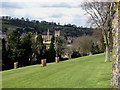
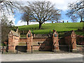
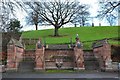
Allerley Well Park
A park in Jedburgh gifted to the town in 1891 by Mr John Tinline. Jedburgh Abbey is prominent in the central background.
Image: © Walter Baxter
Taken: 19 Apr 2008
0.06 miles
2
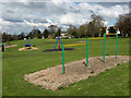
Play area in Allerley Well Park
In the park gifted to the town in 1891 by Mr John Tinline.
Image: © Walter Baxter
Taken: 19 Apr 2008
0.07 miles
3
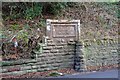
Plaque for the Blaikup Stone, Jedburgh
The plaque is on the E side of the A68, and reads:
Near this spot
the Blaikup Stone
formerly stood
I have not been able to find information about the Blaikup Stone or its history - it would be interesting to know more from those with local knowledge.
Image: © Jim Barton
Taken: 19 Dec 2013
0.08 miles
4
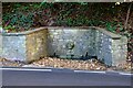
Indian Mutiny Memorial near Jedburgh
A memorial fountain or well by the A68 south of the town. Two local families lost relatives in the Indian Mutiny uprising in 1857, resulting in this memorial fountain by the roadside, dated 1857. The panel is inscribed
To the women and children who suffered in India during the Sepoy mutiny.
The fountain is known locally as the 'Dribbly Well'. (From the information panel on the west side of the road).
Image: © Jim Barton
Taken: 11 Oct 2020
0.09 miles
5
Allerley Well Park, Jedburgh
The main entrance to the park from the A68 on the southern outskirts of the town, with a well in the centre of the red sandstone wall. The park was gifted to the town by Mr John Tinline in 1891.
Image: © Walter Baxter
Taken: 19 Apr 2008
0.10 miles
6
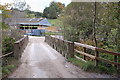
Bridge at Allar's Mill, Jedburgh
A bridge over the Jed Water giving access to the old mill buildings now used as a storage depot.
Image: © Jim Barton
Taken: 4 Oct 2011
0.10 miles
7
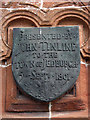
Plaque on the entrance to Allerley Well Park
One of two shields either side of a well at the main entrance to the park from the A68. For a view of the entrance, see Image
Image: © Walter Baxter
Taken: 19 Apr 2008
0.11 miles
8
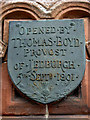
Plaque on the entrance to Allerley Well Park
One of two shields either side of a well at the main entrance to the park from the A68. For a view of the entrance, see Image
Image: © Walter Baxter
Taken: 19 Apr 2008
0.11 miles
9
Allerley Well Park entrance, Jedburgh
Stone steps flanked by decorative pillars on Newcastle Road immediately S of the town.
Image: © Jim Barton
Taken: 19 Dec 2013
0.11 miles
10
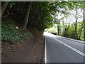
Newcastle Road (A68)
Heading south from Jedburgh.
Image: © JThomas
Taken: 11 Oct 2021
0.12 miles