IMAGES TAKEN NEAR TO
Headrig, JEDBURGH, TD8 6HP
Introduction
This page details the photographs taken nearby to Headrig, TD8 6HP by members of the Geograph project.
The Geograph project started in 2005 with the aim of publishing, organising and preserving representative images for every square kilometre of Great Britain, Ireland and the Isle of Man.

There are currently over 7.5m images from over14,400 individuals and you can help contribute to the project by visiting https://www.geograph.org.uk
Image Map
Images are licensed for reuse under creativecommons.org/licenses/by-sa/2.0
Notes
- Clicking on the map will re-center to the selected point.
- The higher the marker number, the further away the image location is from the centre of the postcode.
Image Listing (40 Images Found)
Images are licensed for reuse under creativecommons.org/licenses/by-sa/2.0
Image
Details
Distance
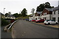
3
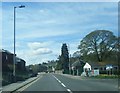
New Housing Estate
At the north end of Jedburgh.
Image: © James Denham
Taken: 18 Feb 2009
0.07 miles
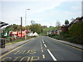
4
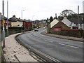
A68 Bongate, Jedburgh
Towards the town centre from the Edinburgh direction.
Image: © Robin Webster
Taken: 24 Dec 2019
0.07 miles
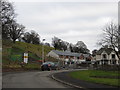
6
The Edinburgh road entering Jedburgh
Running south in to the historic town.
Image: © James Denham
Taken: 18 Feb 2009
0.09 miles
7
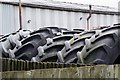
Tractor tyres, Jedburgh
Tyres at the back of the John Deere dealership on the A68.
Image: © Jim Barton
Taken: 25 Jul 2012
0.11 miles

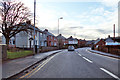
9
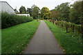
Turf Zone "Bongate"
Path alongside Jed Water, Jedburgh.
Image: © Ian S
Taken: 3 Oct 2022
0.12 miles
10
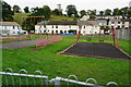
Turf Zone "Priorrigge"
Small play area on Prior's Road, Jedburgh.
Image: © Ian S
Taken: 3 Oct 2022
0.12 miles