IMAGES TAKEN NEAR TO
Elliot Road, JEDBURGH, TD8 6HN
Introduction
This page details the photographs taken nearby to Elliot Road, TD8 6HN by members of the Geograph project.
The Geograph project started in 2005 with the aim of publishing, organising and preserving representative images for every square kilometre of Great Britain, Ireland and the Isle of Man.

There are currently over 7.5m images from over14,400 individuals and you can help contribute to the project by visiting https://www.geograph.org.uk
Image Map
Images are licensed for reuse under creativecommons.org/licenses/by-sa/2.0
Notes
- Clicking on the map will re-center to the selected point.
- The higher the marker number, the further away the image location is from the centre of the postcode.
Image Listing (46 Images Found)
Images are licensed for reuse under creativecommons.org/licenses/by-sa/2.0
Image
Details
Distance
1
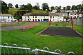
Turf Zone "Priorrigge"
Small play area on Prior's Road, Jedburgh.
Image: © Ian S
Taken: 3 Oct 2022
0.06 miles


6

Postbox on Bongate, Jedburgh
Postbox No. TD8 77.
See Image] for context.
Image: © JThomas
Taken: 12 Oct 2021
0.10 miles
7

Postbox and telephone box on Bongate, Jedburgh
Showing position of Postbox No. TD8 77.
See Image for postbox.
Image: © JThomas
Taken: 12 Oct 2021
0.10 miles
9
Jedburgh from Hartrigge Park
Houses at the north end of the town. The sandstone cliff (centre) has been carved out by the Jed Water, out of sight below.
Image: © Jim Barton
Taken: 23 Sep 2011
0.11 miles