IMAGES TAKEN NEAR TO
Bountrees, JEDBURGH, TD8 6EY
Introduction
This page details the photographs taken nearby to Bountrees, TD8 6EY by members of the Geograph project.
The Geograph project started in 2005 with the aim of publishing, organising and preserving representative images for every square kilometre of Great Britain, Ireland and the Isle of Man.

There are currently over 7.5m images from over14,400 individuals and you can help contribute to the project by visiting https://www.geograph.org.uk
Image Map
Images are licensed for reuse under creativecommons.org/licenses/by-sa/2.0
Notes
- Clicking on the map will re-center to the selected point.
- The higher the marker number, the further away the image location is from the centre of the postcode.
Image Listing (270 Images Found)
Images are licensed for reuse under creativecommons.org/licenses/by-sa/2.0
Image
Details
Distance
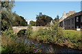
2
Flood defences, Richmond Row
The Jed Water is notorious for flooding and a berm and gate has been fitted to try and keep the river out of these otherwise attractive riverside cottages. I used to have a smaller version to keep the Teviot out of my workplace over in Hawick.
Image: © Richard Webb
Taken: 5 Oct 2009
0.05 miles
3
Houses and trees near Jed Water
Duck Row, the road in the foreground, descends from the A68 in Jedburgh to cross the Jed Water beyond which rises a slope with terraced housing.
Image: © Trevor Littlewood
Taken: 26 Oct 2013
0.05 miles
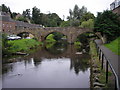
6
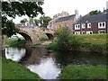
Canongate Bridge
The Canongate Bridge is a 16th-century stone arch bridge that crosses Jed Water in the centre of Jedburgh. The viaduct is built of cream-coloured sandstone and it spans the river with three arches, one of which normally runs over land. The passageway is up to three metres wide. The bridge said to be in desperate need of repair in 1677 and 1770 and repairs took place in 1772.
The Canongate Bridge was built as a road bridge and it has refuges where pedestrians can stand safely whilst heavy traffic passed. The bridge was the main access into the town but it has been closed to motorised traffic for some years.
Image: © Colin Kinnear
Taken: 17 Jul 2020
0.07 miles
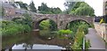
7
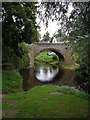
Canongate Bridge, Jedburgh
A 16th century stone bridge over the Jed Water, now restricted to pedestrians.
Image: © Jim Barton
Taken: 23 Sep 2011
0.07 miles
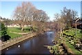
9
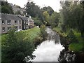
Jed Water
This placid looking stream has a bad reputation for flooding. August 1948 was particularly notorious, but any period of heavy rain causes worries for Borders towns. Richmond Row on the left has now got some defences including a hopefully watertight gate.
Image: © Richard Webb
Taken: 5 Oct 2009
0.08 miles
10
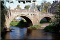
Canongate Bridge, Jedburgh (2)
An attractive stone bridge over the Jed Water, built in the 16th century, now closed to vehicles but still used as a footbridge.
Image: © Jim Barton
Taken: 23 Sep 2011
0.08 miles