IMAGES TAKEN NEAR TO
Muthag Street, SELKIRK, TD7 5DW
Introduction
This page details the photographs taken nearby to Muthag Street, TD7 5DW by members of the Geograph project.
The Geograph project started in 2005 with the aim of publishing, organising and preserving representative images for every square kilometre of Great Britain, Ireland and the Isle of Man.

There are currently over 7.5m images from over14,400 individuals and you can help contribute to the project by visiting https://www.geograph.org.uk
Image Map (Loading...)


Getting Data...Please wait
Leaflet Map data © OpenStreetMap
Images are licensed for reuse under creativecommons.org/licenses/by-sa/2.0
Notes
- Clicking on the map will re-center to the selected point.
- The higher the marker number, the further away the image location is from the centre of the postcode.
Image Listing (93 Images Found)
Images are licensed for reuse under creativecommons.org/licenses/by-sa/2.0
Image
Details
Distance
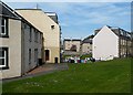
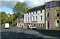
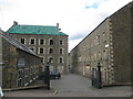
2
Muthag Street Selkirk
Currently a diversion on A707 is in place. The white building centre is Selkirk Scouts.
Image: © Steve Fareham
Taken: 26 May 2013
0.03 miles
3
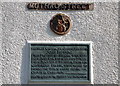
Plaque, Muthag Street Selkirk
A plaque on the corner of a house explaining the history of the street name, commemorating John Muthag, first Provost of Selkirk.
Image: © Jim Barton
Taken: 1 Apr 2012
0.03 miles
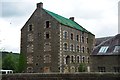
4
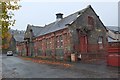
Selkirk Water Works building
A fine old sandstone and whinstone building on Station Road.
Image: © Jim Barton
Taken: 28 Oct 2015
0.06 miles
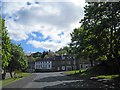
5
Selkirk Scout Hall
Selkirk Scout Hall occupies the upper levels of this block.
Image: © Mary and Angus Hogg
Taken: 7 Oct 2011
0.06 miles
6
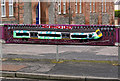
Street art in Selkirk
A group of over 40 knitters called the Selkirk Yarn Bombers, including one aged 104, have covered landmarks in Selkirk and Ettrickbridge with colourful knitted street art which has attracted visitors to admire their handiwork. It was done to promote the Yarrow, Ettrick and Selkirk Festival of Contemporary Arts. This creation representing the new Borders Railway is in Station Road.
Image: © Walter Baxter
Taken: 13 Sep 2015
0.07 miles
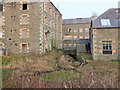
7
Former mill building, Selkirk
A substantial 5-storey building, now derelict, off Station Road.
Image: © Jim Barton
Taken: 12 Jul 2012
0.07 miles
8
Mill lade at Forest Mill, Selkirk
Water from the cauld or weir on the Ettrick Water upstream was channelled here into the complex of textile mills along Dunsdale Road, eventually rejoining the Ettrick about 3km downstream. Part of the lade north of the mills is shown in Image
Image: © Jim Barton
Taken: 13 Dec 2021
0.09 miles
10
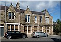
Buildings at Heatherlie Terrace, Selkirk
At one time shops have occupied the ground floor to the right. Two old signs above the windows read – Andrew S Brown Draper and Selkirk Co-operative Society Ltd. A date of 1878 is on a stone panel above the door on the left.
Image: © Walter Baxter
Taken: 9 Aug 2013
0.10 miles