IMAGES TAKEN NEAR TO
Kilncroft, SELKIRK, TD7 5AQ
Introduction
This page details the photographs taken nearby to Kilncroft, TD7 5AQ by members of the Geograph project.
The Geograph project started in 2005 with the aim of publishing, organising and preserving representative images for every square kilometre of Great Britain, Ireland and the Isle of Man.

There are currently over 7.5m images from over14,400 individuals and you can help contribute to the project by visiting https://www.geograph.org.uk
Image Map (Loading...)


Getting Data...Please wait
Leaflet Map data © OpenStreetMap
Images are licensed for reuse under creativecommons.org/licenses/by-sa/2.0
Notes
- Clicking on the map will re-center to the selected point.
- The higher the marker number, the further away the image location is from the centre of the postcode.
Image Listing (154 Images Found)
Images are licensed for reuse under creativecommons.org/licenses/by-sa/2.0
Image
Details
Distance
1
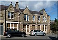
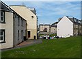
Buildings at Heatherlie Terrace, Selkirk
At one time shops have occupied the ground floor to the right. Two old signs above the windows read – Andrew S Brown Draper and Selkirk Co-operative Society Ltd. A date of 1878 is on a stone panel above the door on the left.
Image: © Walter Baxter
Taken: 9 Aug 2013
0.04 miles
2
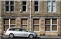
Buildings at Heatherlie Terrace, Selkirk
The ground floor windows either side of the central downpipe have at one time been entrance doors to shops. Old writing above the windows reads:-
ANDREW S BROWN DRAPER and SELKIRK CO-OPERATIVE SOCIETY LTD.
For a wider view of the property, see Image
Image: © Walter Baxter
Taken: 9 Aug 2013
0.04 miles
3
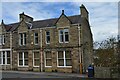
Former Selkirk Co-operative Society premises
A building at Heatherlie Terrace, dated 1886 on the two small panels above the upper windows. See also Walter Baxter's photographs Image and Image for closer views.
Image: © Jim Barton
Taken: 7 May 2021
0.04 miles
4
Muthag Street Selkirk
Currently a diversion on A707 is in place. The white building centre is Selkirk Scouts.
Image: © Steve Fareham
Taken: 26 May 2013
0.06 miles
6
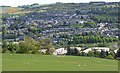
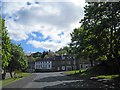
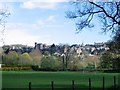
Selkirk from the west
The town seen from the lower slopes of Manor Hill. The light-coloured houses in the foreground are at Bannerfield.
Image: © Jim Barton
Taken: 13 May 2020
0.07 miles
7
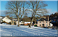
Heatherlie Terrace View
A snowy scene in Selkirk, viewed from Heatherlie Terrace.
Image: © Mary and Angus Hogg
Taken: 14 Jan 2017
0.07 miles
8
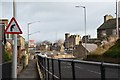
Yarrow Terrace, Selkirk
A road to the town centre up from the Selkirk Bridge. The Sherriff Court building is prominent and the B7009 from Ettrickbridge joins from the right.
Image: © Jim Barton
Taken: 24 Jan 2020
0.07 miles
9
Selkirk
Taken from near Selkirk Bridge, the town rises steeply above the Ettrick Water.
Image: © Richard Webb
Taken: 27 Apr 2005
0.08 miles
10
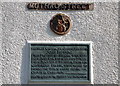
Plaque, Muthag Street Selkirk
A plaque on the corner of a house explaining the history of the street name, commemorating John Muthag, first Provost of Selkirk.
Image: © Jim Barton
Taken: 1 Apr 2012
0.08 miles