IMAGES TAKEN NEAR TO
Ashkirk, SELKIRK, TD7 4NY
Introduction
This page details the photographs taken nearby to TD7 4NY by members of the Geograph project.
The Geograph project started in 2005 with the aim of publishing, organising and preserving representative images for every square kilometre of Great Britain, Ireland and the Isle of Man.

There are currently over 7.5m images from over14,400 individuals and you can help contribute to the project by visiting https://www.geograph.org.uk
Image Map
Images are licensed for reuse under creativecommons.org/licenses/by-sa/2.0
Notes
- Clicking on the map will re-center to the selected point.
- The higher the marker number, the further away the image location is from the centre of the postcode.
Image Listing (45 Images Found)
Images are licensed for reuse under creativecommons.org/licenses/by-sa/2.0
Image
Details
Distance
1

The Woll viewed from the layby on the A7 south of Ashkirk
Ale Water flows from left to right in the valley between the bare field in the foreground and The Woll on the hillside beyond. Near Ancrum, it joins the River Teviot, which enters the River Tweed near Kelso.
Image: © Les Shaw
Taken: 8 May 2008
0.02 miles
2
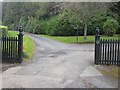
The gates of Woll by Wol
Entrance to a country estate above the Ale Water.
Image: © Oliver Dixon
Taken: 7 Oct 2009
0.04 miles
3
Please don't drive your juggernaut down here!
As it says on this notice at Woll: "Sat Nav incorrect. Unsuitable for motor vehicles." But to be totally idiot-proof, it would have to be accompanied by translations into Romanian, Polish and another dozen European languages.
Image: © Oliver Dixon
Taken: 7 Oct 2009
0.04 miles
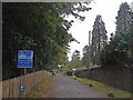
4
Woll Lodge by Wol
Entrance to a country estate above the Ale Water.
Image: © Oliver Dixon
Taken: 7 Oct 2009
0.05 miles
5
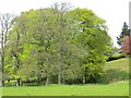
Beeches, Woll
Emerging beech leaves, yet to produce the pigments which darken their leaves.
Image: © Richard Webb
Taken: 11 May 2014
0.09 miles
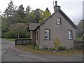
6
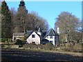
Modern house by the Woll estate
Complete with a fairy-tale turret.
Image: © Oliver Dixon
Taken: 24 Mar 2014
0.10 miles
7
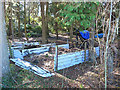
Leafmould generation
Leaf bins in the wooded grounds of Ashkirk House.
Image: © Oliver Dixon
Taken: 24 Mar 2014
0.10 miles
8
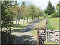
Graveyard, Ashkirk Church
At the eastern end of a small group of housing near the church, which is to the southwest of the village of Ashkirk.
Image: © Barbara Carr
Taken: 5 Jun 2013
0.12 miles
9
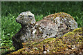
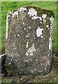
A carving at Ashkirk Parish Churchyard
This is part of a collapsed gravestone. It seems to have the head of a sheep but it is most likely to be a dog. The stone which is lying flat on the ground is inscribed as follows:
ERECTED
BY A FEW FRIENDS
IN MEMORY OF
ROBERT BOLD
SUNDERLANDHALL
WHO DIED 24TH MAY 1880
AGED 73 YEARS
Image: © Walter Baxter
Taken: 4 May 2023
0.12 miles
10
He was only 363 when he died
The inscription on this Crawford gravestone in Ashkirk Parish Churchyard is interesting and amusing because the 18th century mason has carved the age of Robert Crawford as 363 when he died. The inscription reads:
HERE LYES
JOHN CRAWFORD
LATE TENNENT IN
DRAYDIAN WHO
DIED MAY 26 1744
AGID 78
Also Robert Crawford Son
late tenant in Branksholme
Town who died Sept 7 1767
Aged 363 years
For a view of the other side of the stone, see Image
Image: © Walter Baxter
Taken: 13 Nov 2015
0.13 miles