IMAGES TAKEN NEAR TO
SELKIRK, TD7 4NW
Introduction
This page details the photographs taken nearby to TD7 4NW by members of the Geograph project.
The Geograph project started in 2005 with the aim of publishing, organising and preserving representative images for every square kilometre of Great Britain, Ireland and the Isle of Man.

There are currently over 7.5m images from over14,400 individuals and you can help contribute to the project by visiting https://www.geograph.org.uk
Image Map
Images are licensed for reuse under creativecommons.org/licenses/by-sa/2.0
Notes
- Clicking on the map will re-center to the selected point.
- The higher the marker number, the further away the image location is from the centre of the postcode.
Image Listing (30 Images Found)
Images are licensed for reuse under creativecommons.org/licenses/by-sa/2.0
Image
Details
Distance
1
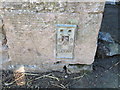
Ordnance Survey Flush Bracket G370
This can be found on the wall of the farmhouse - a private dwelling - at South Common.
For more detail see : http://www.bench-marks.org.uk/bm17571
Image: © Peter Wood
Taken: 14 Oct 2015
0.01 miles
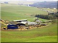
2
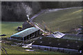
South Common Farm
This farm at Selkirk Common on the southeast side of Selkirk was viewed in late January.
Image: © Walter Baxter
Taken: 28 Jan 2012
0.01 miles
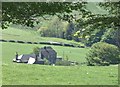
3
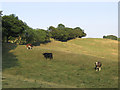
South Common farm
A hill farm on Selkirk Common with cattle and sheep in the pastures.
Image: © Jim Barton
Taken: 3 May 2012
0.02 miles
4
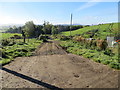
Track to road (A7) from South Common Farm
Looking south-westward.
Image: © Peter Wood
Taken: 14 Oct 2015
0.03 miles
6
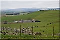
South Common Farm
Viewed from the track between Selkirk and Whitmuir, to the south of the A699.
Image: © Barbara Carr
Taken: 4 Jun 2013
0.03 miles
8
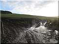
Track to Deepslaids
Deep mud more like it. It is not as bad as it looks, but after a glorious dry Summer, Winter has returned.
Image: © Richard Webb
Taken: 17 Nov 2013
0.13 miles
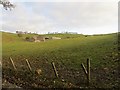
9
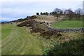
Golf course boundary, Selkirk Hill
Part of Selkirk golf course is to the left with Selkirk Common beyond the wall.
Image: © Jim Barton
Taken: 24 Jan 2020
0.17 miles