IMAGES TAKEN NEAR TO
Kirk Wynd, SELKIRK, TD7 4AW
Introduction
This page details the photographs taken nearby to Kirk Wynd, TD7 4AW by members of the Geograph project.
The Geograph project started in 2005 with the aim of publishing, organising and preserving representative images for every square kilometre of Great Britain, Ireland and the Isle of Man.

There are currently over 7.5m images from over14,400 individuals and you can help contribute to the project by visiting https://www.geograph.org.uk
Image Map
Images are licensed for reuse under creativecommons.org/licenses/by-sa/2.0
Notes
- Clicking on the map will re-center to the selected point.
- The higher the marker number, the further away the image location is from the centre of the postcode.
Image Listing (254 Images Found)
Images are licensed for reuse under creativecommons.org/licenses/by-sa/2.0
Image
Details
Distance
1
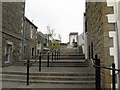
Fleshmarket Close
Steps leading from the Market Place up to Netherview and Back Row.
Image: © M J Richardson
Taken: 18 Apr 2011
0.01 miles
2
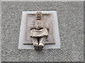
Statue of Souter, Selkirk
Souter is the Scots name for shoemaker.
Shoemaking was the main trade in Selkirk until the textile trade arrived - the Shoemakers' Guild was founded in 1609 and survived until the 1960s. The trade lived on until 1975 when John Guthrie, the last shoemaker, retired. This statue on Kirk Wynd in the area known as Selkirk Regis is a monument to the great tradition. Many people surnamed Souter still live in Selkirk.
(Information from Town Trail booklet.)
Image: © Barbara Carr
Taken: 3 Jun 2013
0.01 miles
3
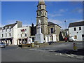
The Square, Selkirk, Scottish Borders
The statue of Sir Walter Scott, the father of the novel. Sir Walter, a legal counsel, was the Sheriff of Selkirkshire for many years. The Sheriff Court is in the background.
Image: © James Denham
Taken: 24 Mar 2008
0.02 miles
4
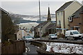
Kirk Wynd, Selkirk
Modern housing on the hill above the Market Place; the hills in the background are across the Tweed.
Image: © Jim Barton
Taken: 30 Dec 2010
0.02 miles
5
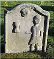
A symbolic gravestone at Selkirk Auld Kirk graveyard
This stone shows the deceased wearing a coat together with a death head’s skull and hourglass which are symbols of mortality. The inscription details on the other side of the stone have weathered away.
Image: © Walter Baxter
Taken: 22 Nov 2015
0.02 miles
6
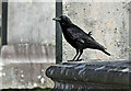
A carrion crow in the graveyard
The bird was on a table tomb at Selkirk Auld Kirk Graveyard.
Image: © Walter Baxter
Taken: 15 Oct 2023
0.02 miles
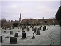
7
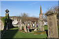
Selkirk Auld Kirk and graveyard
The ruined church on the left is on the site of the Kirk o’ The Forest. The clock tower and spire of the Court House is in the background on the right. There are some interesting symbolic stones in the graveyard.
Image: © Walter Baxter
Taken: 22 Nov 2015
0.02 miles
8
The Kirk o' the Forest
Image: © James Denham
Taken: 29 May 2010
0.03 miles
9
A Selkirk skyline from the Kirk'o' the Forest
Image: © Iain Lees
Taken: 12 Dec 2009
0.03 miles
10
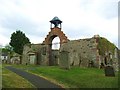
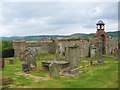
Selkirk Auld Kirk
The auld (old) church, built in 1747, is thought to be at least the third church on the site and is widely believed to be Kirk o' the Forest where Robert Bruce and the rest of the Scottish nobility gathered in the aftermath of the Battle of Stirling Bridge in 1297. The purpose of that meeting was to create William Wallace a knight of the realm, Guardian and Protector of Scotland. The church was falling in to decay by the mid 1800s when a new church was built in the town. the town of Selkirk said to come from Old English 'scheleschirche' meaning church in the woods.
Image: © James Denham
Taken: 29 May 2010
0.03 miles