IMAGES TAKEN NEAR TO
MELROSE, TD6 9HE
Introduction
This page details the photographs taken nearby to TD6 9HE by members of the Geograph project.
The Geograph project started in 2005 with the aim of publishing, organising and preserving representative images for every square kilometre of Great Britain, Ireland and the Isle of Man.

There are currently over 7.5m images from over14,400 individuals and you can help contribute to the project by visiting https://www.geograph.org.uk
Image Map
Images are licensed for reuse under creativecommons.org/licenses/by-sa/2.0
Notes
- Clicking on the map will re-center to the selected point.
- The higher the marker number, the further away the image location is from the centre of the postcode.
Image Listing (6 Images Found)
Images are licensed for reuse under creativecommons.org/licenses/by-sa/2.0
Image
Details
Distance
1

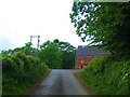
A country road at Greenwells
This narrow road runs from the B6398 between Bowden and Newtown St Boswells to Eildon, just to the north of Newtown St Boswells. It provides access to the farms at Whiterigg and Greenwells.
Image: © Walter Baxter
Taken: 8 Jun 2008
0.09 miles
2
Nearing the Junction at Greenwells Farm
Near the village of Eildon in the Scottish Borders.
Image: © James Denham
Taken: 28 May 2010
0.11 miles
3
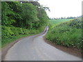
Country road heading for Whiterigg
Near Newtown St. Boswells in the Scottish Borders.
Image: © James Denham
Taken: 28 May 2010
0.11 miles
4
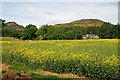
Oil seed rape field at Greenwells
Greenwells Farm is in the mid ground with Eildon Mid Hill on the left and Eildon Hill North on the right in the background.
Image: © Walter Baxter
Taken: 8 Jun 2008
0.12 miles
5

A misty Borders landscape
This early morning telephoto shot was taken from the summit of Eildon Mid Hill with just a few trees poking out above the mist.
Image: © Walter Baxter
Taken: 7 Feb 2020
0.12 miles
6
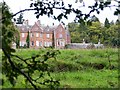
Eildon Hall
Eildon Hall and its surrounding woodland at the foot of the Eildon Hills are part of the Buccleuch Estates.
Image: © Jenny Gumbrell
Taken: 18 Sep 2005
0.19 miles