IMAGES TAKEN NEAR TO
MELROSE, TD6 9BE
Introduction
This page details the photographs taken nearby to TD6 9BE by members of the Geograph project.
The Geograph project started in 2005 with the aim of publishing, organising and preserving representative images for every square kilometre of Great Britain, Ireland and the Isle of Man.

There are currently over 7.5m images from over14,400 individuals and you can help contribute to the project by visiting https://www.geograph.org.uk
Image Map (Loading...)


Getting Data...Please wait
Leaflet Map data © OpenStreetMap
Images are licensed for reuse under creativecommons.org/licenses/by-sa/2.0
Notes
- Clicking on the map will re-center to the selected point.
- The higher the marker number, the further away the image location is from the centre of the postcode.
Image Listing (6 Images Found)
Images are licensed for reuse under creativecommons.org/licenses/by-sa/2.0
Image
Details
Distance
1
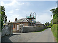
Sunnyside
The chimney lodge to this small complex of properties was being worked on.
Image: © Stephen Craven
Taken: 29 Jun 2019
0.02 miles
2
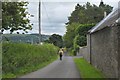
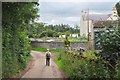
Road passing Sunnyside farm
The minor road to Darnick is access for Kaeside, Sunnyside and Broomilees farms.
Image: © Jim Barton
Taken: 24 Jul 2020
0.03 miles
3
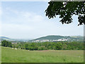
View over Tweedbank
Taken from Broomilees Road, with Buckholme Hill in the distance.
Image: © Stephen Craven
Taken: 29 Jun 2019
0.13 miles
4
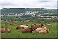
Cows at Kaeside
Houses on the hillside at Langlee are in the background.
Image: © Jim Barton
Taken: 24 Jul 2020
0.20 miles
5
Kaeside farm
On a minor road that descends eastwards to Darnick.
Image: © Jim Barton
Taken: 24 Jul 2020
0.22 miles
6
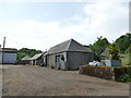
Kaeside, Broomilees Road
A modest farmstead.
Image: © Stephen Craven
Taken: 29 Jun 2019
0.24 miles