IMAGES TAKEN NEAR TO
Langlands Place, MELROSE, TD6 0SF
Introduction
This page details the photographs taken nearby to Langlands Place, TD6 0SF by members of the Geograph project.
The Geograph project started in 2005 with the aim of publishing, organising and preserving representative images for every square kilometre of Great Britain, Ireland and the Isle of Man.

There are currently over 7.5m images from over14,400 individuals and you can help contribute to the project by visiting https://www.geograph.org.uk
Image Map
Images are licensed for reuse under creativecommons.org/licenses/by-sa/2.0
Notes
- Clicking on the map will re-center to the selected point.
- The higher the marker number, the further away the image location is from the centre of the postcode.
Image Listing (84 Images Found)
Images are licensed for reuse under creativecommons.org/licenses/by-sa/2.0
Image
Details
Distance
1
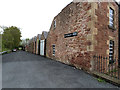
Works at Newtown St Boswells
What appears to be an old mill is now occupied by a motorbike workshop. At the far end of the row an old rail bridge which once carried the Waverley line from Edinburgh to Carlisle can be seen.
Image: © Oliver Dixon
Taken: 5 May 2014
0.02 miles
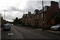
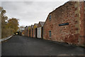
2
Terraced housing, Newtown St Boswells
The terrace in (presumably) red sandstone and on the east side of the B6398.
Image: © Trevor Littlewood
Taken: 2 May 2019
0.02 miles
3
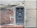
Ordnance Survey Flush Bracket S8173
This can be found on the wall of a former school building now called Newtown Community Link.
For more detail see: http://www.bench-marks.org.uk/bm494
Image: © Peter Wood
Taken: 15 Oct 2015
0.02 miles
5
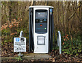
An electric vehicle charging point at Newtown St Boswells
The EV charging point is in a car park opposite the Scottish Borders Council offices.
Image: © Walter Baxter
Taken: 21 Mar 2023
0.04 miles
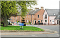
7
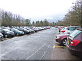
Car park for Scottish Borders Council Offices
A common characteristic of all local Council Offices seems to be the colossal size of their car parks - invariably full to capacity.
Image: © Oliver Dixon
Taken: 18 Mar 2014
0.06 miles
8
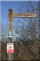
A footpath sign at Newtown St Boswells
On the east side of Langlands Place. The path runs under an old railway bridge and a road bridge over the A68.
Image: © Walter Baxter
Taken: 13 Mar 2010
0.06 miles
9
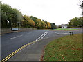
Junction of roads (B6398 and B6340) in Newtown St Boswells
Looking south-eastward.
Image: © Peter Wood
Taken: 15 Oct 2015
0.07 miles
10
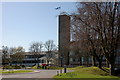
Scottish Borders Council Headquarters, Newtown St Boswells
The main offices of the SBC, comprising the 1960s original building with a more modern extension on the left.
Image: © Jim Barton
Taken: 8 Apr 2011
0.08 miles