IMAGES TAKEN NEAR TO
Burn Brae, MELROSE, TD6 0EH
Introduction
This page details the photographs taken nearby to Burn Brae, TD6 0EH by members of the Geograph project.
The Geograph project started in 2005 with the aim of publishing, organising and preserving representative images for every square kilometre of Great Britain, Ireland and the Isle of Man.

There are currently over 7.5m images from over14,400 individuals and you can help contribute to the project by visiting https://www.geograph.org.uk
Image Map
Images are licensed for reuse under creativecommons.org/licenses/by-sa/2.0
Notes
- Clicking on the map will re-center to the selected point.
- The higher the marker number, the further away the image location is from the centre of the postcode.
Image Listing (9 Images Found)
Images are licensed for reuse under creativecommons.org/licenses/by-sa/2.0
Image
Details
Distance
1
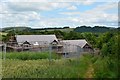
New houses, Newtown St Boswells
New houses under construction near Sergeants Park on the west side of the town.
Image: © Jim Barton
Taken: 14 Jul 2017
0.07 miles
2
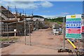
New housing site, Newtown St Boswells
The site is closed off but the standard list of warnings about access is on display.
Image: © Jim Barton
Taken: 14 Jul 2017
0.07 miles
3
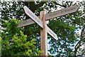
Footpath signpost near Newtown St Boswells
A crossroads of field paths here. The signposts are useful as some of the paths are not heavily used and not obvious from the 1:25,000 maps.
Image: © Jim Barton
Taken: 14 Jul 2017
0.10 miles
4
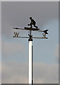
Newtown St Boswells Bowling Club weather vane
The vane is on the west side of the bowling green. For a view of the clubhouse and green, see Image
Image: © Walter Baxter
Taken: 24 Mar 2011
0.16 miles
5
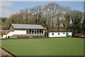
Newtown St Boswells Bowling Club
This attractive bowling green is situated in Sprouston Road.
Image: © Walter Baxter
Taken: 24 Mar 2011
0.17 miles
6
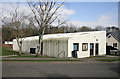
Newtown St Boswells Community Centre
The community centre is situated in Sprouston Road.
Image: © Walter Baxter
Taken: 24 Mar 2011
0.19 miles
7
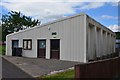
Community Centre, Newtown St Boswells
The Community Centre is situated in Sprouston Road.
Image: © Jim Barton
Taken: 14 Jul 2017
0.19 miles
8
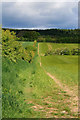
Marked path to Eildon Hills
From the road between Bowden and Newtown St Boswells.
Image: © David Lally
Taken: 27 May 2010
0.25 miles
9
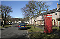
Sprouston Road, Newtown St Boswells
Housing on the northwest side of the village.
Image: © Walter Baxter
Taken: 13 Mar 2010
0.25 miles