IMAGES TAKEN NEAR TO
Roxburgh Road, KELSO, TD5 8TP
Introduction
This page details the photographs taken nearby to Roxburgh Road, TD5 8TP by members of the Geograph project.
The Geograph project started in 2005 with the aim of publishing, organising and preserving representative images for every square kilometre of Great Britain, Ireland and the Isle of Man.

There are currently over 7.5m images from over14,400 individuals and you can help contribute to the project by visiting https://www.geograph.org.uk
Image Map
Images are licensed for reuse under creativecommons.org/licenses/by-sa/2.0
Notes
- Clicking on the map will re-center to the selected point.
- The higher the marker number, the further away the image location is from the centre of the postcode.
Image Listing (8 Images Found)
Images are licensed for reuse under creativecommons.org/licenses/by-sa/2.0
Image
Details
Distance
1
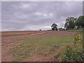
Farmland near Heiton
Potatoes ready for harvest.
Image: © wfmillar
Taken: 26 Sep 2010
0.03 miles
3
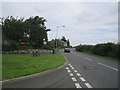
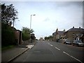
Heighton
A698 on the southern edge of Heighton.
Image: © Richard Webb
Taken: 14 Aug 2012
0.04 miles
4
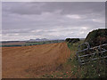
Farmland near Heiton
View of the Eildon Hills in the distance.
Image: © wfmillar
Taken: 26 Sep 2010
0.07 miles
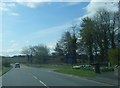
5
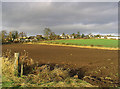
Farmland at Heiton
Viewed from the A698 at the southern edge of the village.
Image: © Walter Baxter
Taken: 24 Nov 2007
0.09 miles
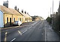
6
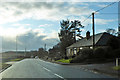
A698 Main Street, Heiton
Leaving the village towards Jedburgh.
Image: © Robin Webster
Taken: 24 Dec 2019
0.09 miles
7
Heiton in Roxburghshire
The A698 running through the village towards Kelso.
Image: © James Denham
Taken: 25 Sep 2008
0.13 miles