IMAGES TAKEN NEAR TO
The Square, KELSO, TD5 8QL
Introduction
This page details the photographs taken nearby to The Square, TD5 8QL by members of the Geograph project.
The Geograph project started in 2005 with the aim of publishing, organising and preserving representative images for every square kilometre of Great Britain, Ireland and the Isle of Man.

There are currently over 7.5m images from over14,400 individuals and you can help contribute to the project by visiting https://www.geograph.org.uk
Image Map
Images are licensed for reuse under creativecommons.org/licenses/by-sa/2.0
Notes
- Clicking on the map will re-center to the selected point.
- The higher the marker number, the further away the image location is from the centre of the postcode.
Image Listing (62 Images Found)
Images are licensed for reuse under creativecommons.org/licenses/by-sa/2.0
Image
Details
Distance
1
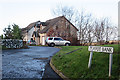
Teapot Bank
Teapot Bank is a cul-de-sac off Teapot Street. There is a possibly (or even probably) apocryphal tale that Sir Walter Scott, observing some women carrying teapots along the road, said that it must be Teapot Street, and the name stuck.
Image: © Anne Burgess
Taken: 1 Jan 2018
0.05 miles
2
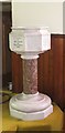
The Baptismal Font at Morebattle Church
In Roxburghshire.
Image: © James Denham
Taken: 11 Jun 2013
0.07 miles
3
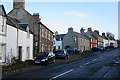
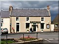
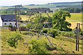
Morebattle Village
This is the main street of Morebattle, all but deserted on New Year's morning.
Image: © Anne Burgess
Taken: 1 Jan 2018
0.07 miles
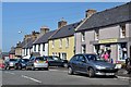
4
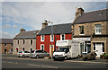
Main Street in Morebattle
Houses on the north side of the street. Now where have I seen that butcher's van before Image
Image: © Walter Baxter
Taken: 4 Jul 2009
0.07 miles
5
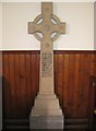
Memorial in Morebattle Parish Church
To the brave men of the parish who perished in the Boer War of 1899-1902.
Image: © James Denham
Taken: 11 Jun 2013
0.07 miles
7
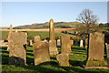
Morebattle Parish Churchyard
There are some interesting old stones in the graveyard. Viewed from the path to the church.
Image: © Walter Baxter
Taken: 24 Oct 2008
0.07 miles
8
Main street, Morebattle
A nearby information board notes that the village's name does not refer to a battle but is from the Anglian 'mere-botl' or lake dwelling, referring to the former Linton Loch that was drained in the 18th century. The village shop opens for mornings only and has a sign in the window 'Use us or lose us'.
Image: © Jim Barton
Taken: 8 Jul 2013
0.07 miles
9
An unusual pylon, Morebattle
A short square section tower carrying a power line to the N of the village.
Image: © Jim Barton
Taken: 8 Jul 2013
0.07 miles
10
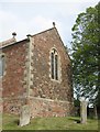
Morebattle Church
The east wall and a section of south wall of the chancel, the lower sections of which, are medieval.
Image: © James Denham
Taken: 11 Jun 2013
0.07 miles