IMAGES TAKEN NEAR TO
KELSO, TD5 8EF
Introduction
This page details the photographs taken nearby to TD5 8EF by members of the Geograph project.
The Geograph project started in 2005 with the aim of publishing, organising and preserving representative images for every square kilometre of Great Britain, Ireland and the Isle of Man.

There are currently over 7.5m images from over14,400 individuals and you can help contribute to the project by visiting https://www.geograph.org.uk
Image Map
Images are licensed for reuse under creativecommons.org/licenses/by-sa/2.0
Notes
- Clicking on the map will re-center to the selected point.
- The higher the marker number, the further away the image location is from the centre of the postcode.
Image Listing (9 Images Found)
Images are licensed for reuse under creativecommons.org/licenses/by-sa/2.0
Image
Details
Distance
1
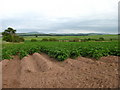
Field of Potatoes at Whinnyhouse, near Morebattle
Image: © Lisa Jarvis
Taken: 24 Jun 2006
0.08 miles
2
Oilseed rape, Fountainhead
Harvest in progress but there is rain about.
Image: © Richard Webb
Taken: 14 Aug 2012
0.16 miles
3
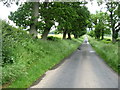
The road from Cessford
Heading toward the junction with Kelso to Morebattle road.
Image: © James Denham
Taken: 29 Jun 2012
0.21 miles
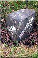
4
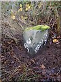
Old milestone
After clearing overgrown vegetation from this milestone, the white painted legend is still clear after 11 years of Border weather. It is a short distance south of Whinnyhouse which is on the east side of the road. This part of Borders was Roxburghshire prior to the 1970s.
Image: © Chris Minto
Taken: 23 Oct 2022
0.21 miles
5
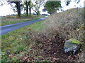
Old milestone
The road southwards from the Kelso 7 milestone.
Image: © Chris Minto
Taken: 23 Oct 2022
0.21 miles
6
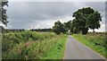
Minor road near Cessford
A steady climb past Fountainhead.
Image: © Richard Webb
Taken: 14 Aug 2012
0.21 miles
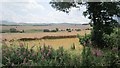
7
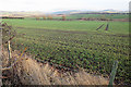
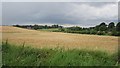
Field near Fountain Head
The field slopes down to the Tanlaw Burn. The crop is winter cereal.
Image: © Anne Burgess
Taken: 1 Jan 2018
0.22 miles
8
Old Milestone by Fountain Head, Eckford parish
Stone post by the UC road, in parish of Eckford (Roxburgh District), North of Cessford, on grass verge just South of Whinnyhouse.
Inscription reads:-
: KELSO / 7 : : JEDBURGH / 7 :
Surveyed
Milestone Society National ID: BD_KSJBUC07
Image: © Milestone Society
Taken: Unknown
0.23 miles
9
Barley field, Marlefield
The harvest was in progress nearby.
Image: © Richard Webb
Taken: 14 Aug 2012
0.23 miles