IMAGES TAKEN NEAR TO
Spylaw Road, KELSO, TD5 8DL
Introduction
This page details the photographs taken nearby to Spylaw Road, TD5 8DL by members of the Geograph project.
The Geograph project started in 2005 with the aim of publishing, organising and preserving representative images for every square kilometre of Great Britain, Ireland and the Isle of Man.

There are currently over 7.5m images from over14,400 individuals and you can help contribute to the project by visiting https://www.geograph.org.uk
Image Map (Loading...)


Getting Data...Please wait
Leaflet Map data © OpenStreetMap
Images are licensed for reuse under creativecommons.org/licenses/by-sa/2.0
Notes
- Clicking on the map will re-center to the selected point.
- The higher the marker number, the further away the image location is from the centre of the postcode.
Image Listing (18 Images Found)
Images are licensed for reuse under creativecommons.org/licenses/by-sa/2.0
Image
Details
Distance
1
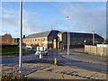
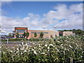
Former cake and fertilizer factory, Kelso
Even earlier mapped as a manure works. I hope the cake was cattle cake and not directly for human consumption.
Image: © Robin Webster
Taken: 24 Dec 2019
0.03 miles
2
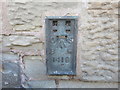
Ordnance Survey Flush Bracket 1418
This can be found on the wall of a building at the junction of Spylaw Road and the B6352.
For more detail see : http://www.bench-marks.org.uk/bm843
Image: © Peter Wood
Taken: 12 Oct 2015
0.04 miles
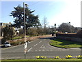
3
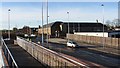
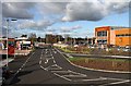
New roundabout, Kelso
A staggered crossroads on the bypass has been replaced with a roundabout as an entrance to a new supermarket. The foreground is a ramp providing pedestrian access.
Image: © Richard Webb
Taken: 12 Jan 2012
0.05 miles
4
On A698 Kelso by-pass, near site of former Kelso station, 2000
View NE, the station having been about 100 yards ahead: ex-NBR/NER St Boswells -Kelso - Sprouston - Coldstream - Tweedmouth line, closed to passengers 15/6/64, to goods 13/3/68; the NBR section extended almost to Sprouston, making an end-on junction with the NER section, which then crossed the Border at Carham. By 2000, the site of Kelso station was obscured by a new roundabout.
Image: © Ben Brooksbank
Taken: 28 Jun 2000
0.08 miles
6
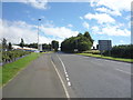
Sainsbury's at Kelso
This new store was opened on 12th October 2011 at Pinnacle Estate on the southeast side of the town. The supermarket chain won a long running battle with Tesco to build a store in Kelso. A new roundabout was formed on the A698 to provide access to the store and the Pinnaclehill area by removing the existing T-junction with Yetholm Road and Station Road. This shows the access road to the store car park with a Sainsbury’s filling station on the left.
Image: © Walter Baxter
Taken: 19 Oct 2011
0.13 miles
7
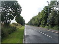
B6352, Kelso
Looking south east near the supermarket.
Image: © JThomas
Taken: 8 Sep 2016
0.13 miles
9

Sainsbury's Store at Kelso
This new store was opened on 12th October 2011 at Pinnacle Estate on the southeast side of the town. The supermarket chain won a long running battle with Tesco to build a store in Kelso. A new roundabout was formed on the A698 to provide access to the store and the Pinnaclehill area by removing the existing T-junction with Yetholm Road and Station Road.
Image: © Walter Baxter
Taken: 19 Oct 2011
0.14 miles
10
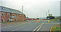
Sprouston Road from Station Road, Kelso
Image: © Jonathan Hutchins
Taken: 8 Apr 2010
0.16 miles