IMAGES TAKEN NEAR TO
Springwood Bank, KELSO, TD5 8BA
Introduction
This page details the photographs taken nearby to Springwood Bank, TD5 8BA by members of the Geograph project.
The Geograph project started in 2005 with the aim of publishing, organising and preserving representative images for every square kilometre of Great Britain, Ireland and the Isle of Man.

There are currently over 7.5m images from over14,400 individuals and you can help contribute to the project by visiting https://www.geograph.org.uk
Image Map
Images are licensed for reuse under creativecommons.org/licenses/by-sa/2.0
Notes
- Clicking on the map will re-center to the selected point.
- The higher the marker number, the further away the image location is from the centre of the postcode.
Image Listing (70 Images Found)
Images are licensed for reuse under creativecommons.org/licenses/by-sa/2.0
Image
Details
Distance
1
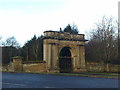
Gates at the entrance to Springwood Park
The so-called 'Douglas Gates' at the entrance to Springwood Park, Kelso. In the ownership of the Douglas clan for over 200 years, the great house was demolished in 1969.
Image: © Jonathan Hutchins
Taken: 3 Apr 2010
0.09 miles
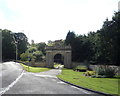
3
Springwood Park Gateway
The gateway to a demolished mansion
Image: © Kevin Waterhouse
Taken: 16 Sep 2016
0.13 miles
4
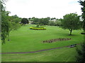
Bridgend Park, Kelso
Very attractive small park just south of the River Tweed.
Image: © G Laird
Taken: 1 Jul 2017
0.13 miles
5
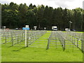
Sheep pens, Border Union Show
Something is missing from this photo, can you spot what it is? There were no sheep and only a few cattle on site. Presumably judging takes place on day 2 which is unusual.
Image: © Richard Webb
Taken: 26 Jul 2024
0.15 miles
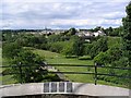
6
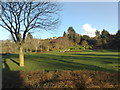
Bridgend Park, Kelso
Looking towards the south-eastern corner of the park which rises up to the Millennium Viewpoint
Image: © Jonathan Hutchins
Taken: 1 Apr 2010
0.15 miles
7
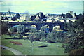
Brigend Park
View from Maxwellheugh, over the riverside park, towards Kelso Bridge and the town of Kelso. The tower of the ruined abbey is to the right.
http://www.kelso.bordernet.co.uk/
Image: © Colin Smith
Taken: 1 Aug 1985
0.16 miles
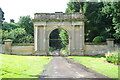
8
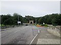
Southern end of Kelso Bridge
The A699 goes right at this junction around Springwood Park. The mansion was built in 1756 and demolished in 1954 but the main entrance from those days still survives in the centre, built in 1822
Image: © Martin Dawes
Taken: 12 Sep 2019
0.16 miles
9
Bridgend Park, Kelso
This is a view over the park from Kelso Millennium viewpoint at Maxwellheugh. The viewpoint offers a wonderful panoramic view to Kelso Bridge and the town skyline. The foreground metal panels represent and are inscribed from left to right – Floors Castle, North Kirk, Town Hall and Abbey. For an October view of Kelso Bridge and the town from this viewpoint, see Image
Image: © Walter Baxter
Taken: 25 May 2007
0.16 miles
10
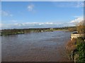
River Tweed in Flood
Taken January 2005 looking upstream from the Rennie bridge, see image Image for a normal summer view.
Image: © Hill Walker
Taken: 8 Jan 2005
0.17 miles