IMAGES TAKEN NEAR TO
KELSO, TD5 8AW
Introduction
This page details the photographs taken nearby to TD5 8AW by members of the Geograph project.
The Geograph project started in 2005 with the aim of publishing, organising and preserving representative images for every square kilometre of Great Britain, Ireland and the Isle of Man.

There are currently over 7.5m images from over14,400 individuals and you can help contribute to the project by visiting https://www.geograph.org.uk
Image Map
Images are licensed for reuse under creativecommons.org/licenses/by-sa/2.0
Notes
- Clicking on the map will re-center to the selected point.
- The higher the marker number, the further away the image location is from the centre of the postcode.
Image Listing (13 Images Found)
Images are licensed for reuse under creativecommons.org/licenses/by-sa/2.0
Image
Details
Distance
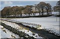
1
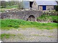
Bridge over the Mainhope Burn at the Yett
South of Hounam in Roxburghshire.
Image: © James Denham
Taken: 6 May 2014
0.03 miles
2
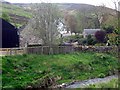
The Yett, in Roxburghshire
A view of the farm from across the Mainhope Burn.
Image: © James Denham
Taken: 6 May 2014
0.04 miles
3
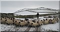
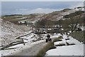
Hesitant Sheep
The sheep have been driven down from the moors, but seem reluctant to pass through the gate into the farmyard and pens. In the background is Great Rough Law.
Image: © Anne Burgess
Taken: 30 Dec 2017
0.05 miles
4
Sheep on the Move
Assisted by two collies, the shepherd has persuaded the sheep to pass through the gate and they are about to find themselves in a pen where they will be treated for parasites. The hills on the skyline are Little Rough Law (on the left) and Great Rough Law (on the right).
Image: © Anne Burgess
Taken: 30 Dec 2017
0.05 miles
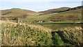
5
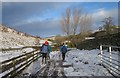
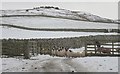
Icy Road at The Yett
The public road ends at The Yett but there is a good track up the glen. At least, it would be good if it were not dangerously icy!
Image: © Anne Burgess
Taken: 30 Dec 2017
0.05 miles
6
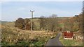
Track near The Yett
The farm buildings at The Yett are just in the next square, but the foreground is in this square. I sometimes think I would like to have a quad bike for geographing, but of course it would be necessary to get permission to use it off the public road.
Image: © Anne Burgess
Taken: 30 Dec 2017
0.11 miles
7
Road, Greenhill
An old railway wagon being used as an agricultural building. This is a common sight in the Cheviot Hills.
Image: © Richard Webb
Taken: 19 Nov 2011
0.11 miles
8
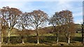
Beeches, Greenhill
Mature beeches growing off an earthbank, a former field boundary.
Image: © Richard Webb
Taken: 19 Nov 2011
0.14 miles
9
Capehope Burn
A dyke on one side and wooden fences on the other serve to keep livestock out of the burn as it approaches Greenhill.
Image: © Anne Burgess
Taken: 30 Dec 2017
0.14 miles
10
The Yett
There has been some recent woodland planting here.
Image: © Richard Webb
Taken: 19 Nov 2011
0.16 miles