IMAGES TAKEN NEAR TO
KELSO, TD5 8AH
Introduction
This page details the photographs taken nearby to TD5 8AH by members of the Geograph project.
The Geograph project started in 2005 with the aim of publishing, organising and preserving representative images for every square kilometre of Great Britain, Ireland and the Isle of Man.

There are currently over 7.5m images from over14,400 individuals and you can help contribute to the project by visiting https://www.geograph.org.uk
Image Map
Images are licensed for reuse under creativecommons.org/licenses/by-sa/2.0
Notes
- Clicking on the map will re-center to the selected point.
- The higher the marker number, the further away the image location is from the centre of the postcode.
Image Listing (7 Images Found)
Images are licensed for reuse under creativecommons.org/licenses/by-sa/2.0
Image
Details
Distance
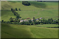
1
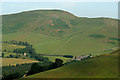
Hownam Grange Farm
Just visible over the north ridge of Wether Hill with Hownam Law dominant in the background.
Image: © Walter Baxter
Taken: 29 Jun 2009
0.03 miles
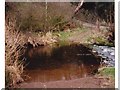
3
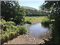
Hownam Grange Ford
This ford on Kale Water is found at Hownam Grange.
Image: © John Walton
Taken: 28 Jun 2018
0.11 miles
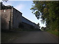
4
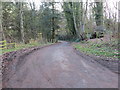
Minor road leading to Hownam Grange
Looking south-eastward.
Image: © Peter Wood
Taken: 12 Dec 2018
0.15 miles
7
Gateshaw Farm
This is a view from the west end of Hownam Law.
Image: © Walter Baxter
Taken: 24 Jun 2011
0.24 miles