IMAGES TAKEN NEAR TO
KELSO, TD5 8AD
Introduction
This page details the photographs taken nearby to TD5 8AD by members of the Geograph project.
The Geograph project started in 2005 with the aim of publishing, organising and preserving representative images for every square kilometre of Great Britain, Ireland and the Isle of Man.

There are currently over 7.5m images from over14,400 individuals and you can help contribute to the project by visiting https://www.geograph.org.uk
Image Map
Images are licensed for reuse under creativecommons.org/licenses/by-sa/2.0
Notes
- Clicking on the map will re-center to the selected point.
- The higher the marker number, the further away the image location is from the centre of the postcode.
Image Listing (16 Images Found)
Images are licensed for reuse under creativecommons.org/licenses/by-sa/2.0
Image
Details
Distance
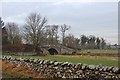
1
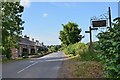
B6436 at Morebattle Tofts
Cottages alongside the road to Kelso with the farm sign and footpath signpost for the Jubilee Bridge.
Image: © Jim Barton
Taken: 8 Jul 2013
0.01 miles
2
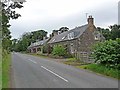
Cottages at Morebattle Tofts
Beside the B6436.
Image: © Oliver Dixon
Taken: 2 Aug 2012
0.02 miles
3
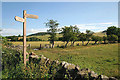
A signpost for the St Cuthbert's Way
On the east side of the B6436 at Morebattle Tofts. The path to the right meets up with the St Cuthbert's Way on Grubbit Law.
Image: © Walter Baxter
Taken: 4 Jul 2009
0.03 miles
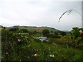
4
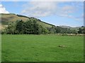
Field, Morebattle Tofts
Beside the Kale Water.
Image: © Richard Webb
Taken: 22 Aug 2012
0.06 miles
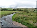
6
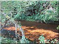
Kale Water at Morebattle
Kale Water rises as Long Burn, on Leap Hill, one of the central Cheviots, near the English Border. It then runs northeast through Oxnam, Hounam and Morebattle and then turns west-north-westward finally entering into the Teviot at Kalemouth, near Kelso.
Image: © Lisa Jarvis
Taken: 24 Jun 2006
0.11 miles
7
The Kale Water
The low lying floodplain of the Kale Water in the foreground was once part of Linton Loch, an extensive stretch of water which was only finally drained in the 18th century.
Image: © Oliver Dixon
Taken: 2 Aug 2012
0.12 miles
8
Upper valley of the Kale Water
The low lying floodplain of the Kale Water in the foreground was once part of Linton Loch, an extensive stretch of water which was only finally drained in the 18th century.
Image: © Oliver Dixon
Taken: 2 Aug 2012
0.12 miles
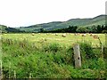
9
Kale Water
The river below Morebattle.
Image: © Richard Webb
Taken: 22 Aug 2012
0.13 miles
10
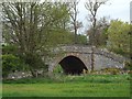
Bridge over the Kale Water
Near Morebattle Tofts.
Image: © James Denham
Taken: 3 May 2014
0.13 miles