IMAGES TAKEN NEAR TO
KELSO, TD5 7SB
Introduction
This page details the photographs taken nearby to TD5 7SB by members of the Geograph project.
The Geograph project started in 2005 with the aim of publishing, organising and preserving representative images for every square kilometre of Great Britain, Ireland and the Isle of Man.

There are currently over 7.5m images from over14,400 individuals and you can help contribute to the project by visiting https://www.geograph.org.uk
Image Map
Images are licensed for reuse under creativecommons.org/licenses/by-sa/2.0
Notes
- Clicking on the map will re-center to the selected point.
- The higher the marker number, the further away the image location is from the centre of the postcode.
Image Listing (4 Images Found)
Images are licensed for reuse under creativecommons.org/licenses/by-sa/2.0
Image
Details
Distance
1
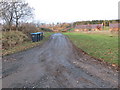
Track to Mellerstain Mill
Looking north-westward.
Image: © Peter Wood
Taken: 9 Dec 2018
0.03 miles
3
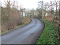
Minor road and Mellowlees Bridge crossing Eden Water
Looking eastward.
Image: © Peter Wood
Taken: 9 Dec 2018
0.16 miles
4
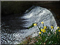
The Waterfall Mellerstain Lake
Narcissa watch for trout leaping up the falls. This is the outflow of the Eden Burn from Mellerstain Lake.
Image: © John Haddington
Taken: 20 Apr 2008
0.24 miles