IMAGES TAKEN NEAR TO
KELSO, TD5 7RR
Introduction
This page details the photographs taken nearby to TD5 7RR by members of the Geograph project.
The Geograph project started in 2005 with the aim of publishing, organising and preserving representative images for every square kilometre of Great Britain, Ireland and the Isle of Man.

There are currently over 7.5m images from over14,400 individuals and you can help contribute to the project by visiting https://www.geograph.org.uk
Image Map
Images are licensed for reuse under creativecommons.org/licenses/by-sa/2.0
Notes
- Clicking on the map will re-center to the selected point.
- The higher the marker number, the further away the image location is from the centre of the postcode.
Image Listing (16 Images Found)
Images are licensed for reuse under creativecommons.org/licenses/by-sa/2.0
Image
Details
Distance
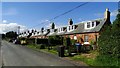
1
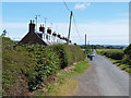
Farm cottages at Haymount
The Borders Abbeys Way, a circular long-distance walking route in the Scottish Borders, passes along this quiet country road.
Image: © Oliver Dixon
Taken: 9 Jul 2014
0.02 miles
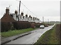
2
Farm cottages at Haymount
The Borders Abbeys Way, a circular long-distance walking route in the Scottish Borders, passes along this quiet country road.
Image: © Oliver Dixon
Taken: 9 Jul 2014
0.03 miles
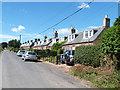
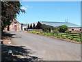
3
Haymount
Typical rural housing in the South East. These would have been cottages for the workers on Haymount Farm.
Image: © Richard Webb
Taken: 3 Dec 2006
0.03 miles
8
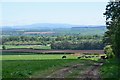
Across the Tweed to the Cheviot
Looking from Haymount across farmland to The Cheviot in the distance.
Image: © Jim Barton
Taken: 16 May 2019
0.13 miles
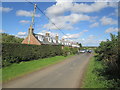
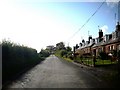
9
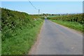
Road to Haymount
The minor road up from the B6397 near Wester Muirdean.
Image: © Jim Barton
Taken: 16 May 2019
0.16 miles
10
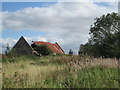
Ruined farm building at Luntonlaw
From the B.A.Way following the road toward B6397
Image: © Martin Dawes
Taken: 11 Sep 2019
0.17 miles