IMAGES TAKEN NEAR TO
KELSO, TD5 7QD
Introduction
This page details the photographs taken nearby to TD5 7QD by members of the Geograph project.
The Geograph project started in 2005 with the aim of publishing, organising and preserving representative images for every square kilometre of Great Britain, Ireland and the Isle of Man.

There are currently over 7.5m images from over14,400 individuals and you can help contribute to the project by visiting https://www.geograph.org.uk
Image Map
Images are licensed for reuse under creativecommons.org/licenses/by-sa/2.0
Notes
- Clicking on the map will re-center to the selected point.
- The higher the marker number, the further away the image location is from the centre of the postcode.
Image Listing (13 Images Found)
Images are licensed for reuse under creativecommons.org/licenses/by-sa/2.0
Image
Details
Distance
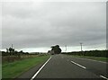
1
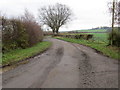
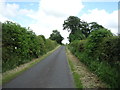
Minor road at Highridgehall
Looking eastward.
Image: © Peter Wood
Taken: 11 Dec 2018
0.02 miles
2
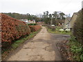
Farm track at Highridgehall
Looking north-eastward.
Image: © Peter Wood
Taken: 11 Dec 2018
0.04 miles
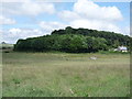
5
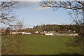
Farmland at Highridgehall
Viewed from the northeast side of Edenmouth Bridge at the A698.
Image: © Walter Baxter
Taken: 11 Mar 2011
0.16 miles
9
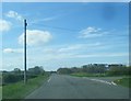
A698 toward Birgham at Highridgehall junction
Turn left for barn, holiday cottages or B & B. The River Tweed is one field away on the right
Image: © Martin Dawes
Taken: 6 Oct 2022
0.22 miles
10
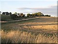
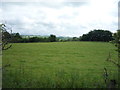
Stubble, Eden Hall
Stubble field beside the curving driveway of Eden Hall.
Image: © Richard Webb
Taken: 4 Oct 2007
0.23 miles