IMAGES TAKEN NEAR TO
Dyers Court, KELSO, TD5 7NQ
Introduction
This page details the photographs taken nearby to Dyers Court, TD5 7NQ by members of the Geograph project.
The Geograph project started in 2005 with the aim of publishing, organising and preserving representative images for every square kilometre of Great Britain, Ireland and the Isle of Man.

There are currently over 7.5m images from over14,400 individuals and you can help contribute to the project by visiting https://www.geograph.org.uk
Image Map
Images are licensed for reuse under creativecommons.org/licenses/by-sa/2.0
Notes
- Clicking on the map will re-center to the selected point.
- The higher the marker number, the further away the image location is from the centre of the postcode.
Image Listing (30 Images Found)
Images are licensed for reuse under creativecommons.org/licenses/by-sa/2.0
Image
Details
Distance
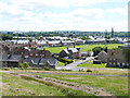
1
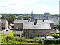
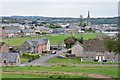
View over Kelso
View south from the Meadows overlooking the town. The road in front is Croft Road, beyond that the large lart-topped building is Kelso High School. In the distance, the imposing spire of Kelso North Parish Church.
Image: © Oliver Dixon
Taken: 9 Jul 2014
0.09 miles
2
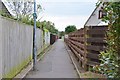
Borders Abbeys Way in Kelso's suburbs
The Borders Abbeys Way takes this footpath between the houses from Golf Course Road to Croft Road where it makes for the riverside walk before crossing the Tweed.
Image: © Jim Barton
Taken: 3 Sep 2014
0.13 miles
3
The Borders Abbeys Way in the suburbs of Kelso
The Borders Abbeys Way, a circular long-distance walking route in the Scottish Borders here follows a straight passageway between the backs of the houses of Dean's Court (to the left) and Weaver's Court (to the right). The W symbol indicates the Way.
Image: © Oliver Dixon
Taken: 9 Jul 2014
0.13 miles
4
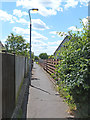
Path near Croft Park, Kelso
The path is on the route of the Borders Abbeys Way as it heads for the Tweed before crossing Rennies Bridge and onwards to Jedburgh.
Image: © Jim Barton
Taken: 3 Sep 2014
0.14 miles
5
View over Kelso
Seen from the zig-zag path which descends to the Meadows overlooking the town. In the foreground is Croft Road, while beyond is the ground of the Kelso Rugby Football Club. In the distance is the imposing spire of Kelso North Parish Church.
Image: © Oliver Dixon
Taken: 9 Jul 2014
0.16 miles
6
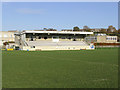
Kelso Rugby Football Club Stand
On the northwest side of the rugby football ground at Poynder Park.
Image: © Walter Baxter
Taken: 6 Nov 2007
0.16 miles
7
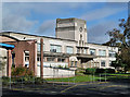
Kelso High School
This is a view of the original 1936 Art Deco principal block. The school was extended in 1978 and 1994 but Scottish Borders Council has recently approved plans for a new secondary school to be built at Angraflat Road.
Image: © Walter Baxter
Taken: 19 Oct 2014
0.17 miles
8
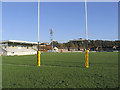
Poynder Park
The home of Kelso Rugby Football Club. The first team are playing this season in B.T. Scotland Premier Division 2 and in the Border League. The club was formed in 1876.
Image: © Walter Baxter
Taken: 6 Nov 2007
0.18 miles
9
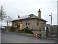
Lodge, Queen's House
Just off Angraflat Road.
Image: © JThomas
Taken: 5 May 2016
0.18 miles
10
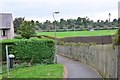
View to Poynder Park, Kelso
A good prospect of the town opens out on the steep little bank above Croft Road. Kelso Rugby Football Club's ground is in the centre. The Borders Abbeys Way contours to the right here to Croft Park.
Image: © Jim Barton
Taken: 3 Sep 2014
0.18 miles