IMAGES TAKEN NEAR TO
Kirkpark, GORDON, TD3 6NR
Introduction
This page details the photographs taken nearby to Kirkpark, TD3 6NR by members of the Geograph project.
The Geograph project started in 2005 with the aim of publishing, organising and preserving representative images for every square kilometre of Great Britain, Ireland and the Isle of Man.

There are currently over 7.5m images from over14,400 individuals and you can help contribute to the project by visiting https://www.geograph.org.uk
Image Map
Images are licensed for reuse under creativecommons.org/licenses/by-sa/2.0
Notes
- Clicking on the map will re-center to the selected point.
- The higher the marker number, the further away the image location is from the centre of the postcode.
Image Listing (47 Images Found)
Images are licensed for reuse under creativecommons.org/licenses/by-sa/2.0
Image
Details
Distance
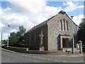
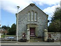
1

Westruther Parish Church and War Memorial
A simple Celtic Cross with Runic symbols.
Image: © Alan Reid
Taken: 19 Jul 2016
0.03 miles
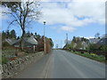
4
Westruther
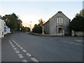
Not as much snow on the inland side of the Lammermuir Hills as over on the seaward side.
Image: © Richard Webb
Taken: 27 Mar 2013
0.04 miles
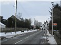
6
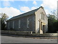
Westruther Parish Church and War Memorial
The 'New Church' referred to in Image
Image: © M J Richardson
Taken: 26 Oct 2022
0.04 miles
8
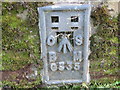
Ordnance Survey Flush Bracket G335
This can be found on the wall of Westruther Church.
For more detail see : http://www.bench-marks.org.uk/bm177
Image: © Peter Wood
Taken: 12 Oct 2015
0.04 miles
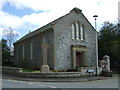
9
Westruther Parish Church
Viewed from the west.
Image: © Peter Wood
Taken: 12 Oct 2015
0.04 miles