IMAGES TAKEN NEAR TO
GORDON, TD3 6NG
Introduction
This page details the photographs taken nearby to TD3 6NG by members of the Geograph project.
The Geograph project started in 2005 with the aim of publishing, organising and preserving representative images for every square kilometre of Great Britain, Ireland and the Isle of Man.

There are currently over 7.5m images from over14,400 individuals and you can help contribute to the project by visiting https://www.geograph.org.uk
Image Map (Loading...)


Getting Data...Please wait
Leaflet Map data © OpenStreetMap
Images are licensed for reuse under creativecommons.org/licenses/by-sa/2.0
Notes
- Clicking on the map will re-center to the selected point.
- The higher the marker number, the further away the image location is from the centre of the postcode.
Image Listing (12 Images Found)
Images are licensed for reuse under creativecommons.org/licenses/by-sa/2.0
Image
Details
Distance
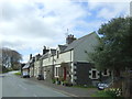
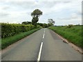
3
B6456 through Thornydykes
Thornydykes is a hamlet southwest of Westruther on the B6456.
Image: © Barbara Carr
Taken: 30 Apr 2013
0.07 miles
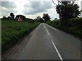
6
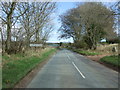
Entering Thorneydykes
Looking north east on the B6456.
Image: © JThomas
Taken: 20 Apr 2017
0.11 miles
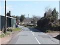
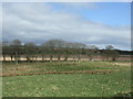
7
Farmland at Thornydykes
Rough pasture, Beech trees along a burn, and sheep pasture.
Image: © M J Richardson
Taken: 11 Nov 2022
0.12 miles
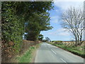
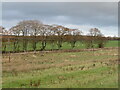
8
Farmland at Thornydykes
Rough pasture, sheep pasture and conifer plantations.
Image: © M J Richardson
Taken: 11 Nov 2022
0.12 miles
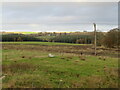
10

Scrubby woodland, Howlets Ha'
A wet area under young trees and weeds.
Image: © Richard Webb
Taken: 27 Jul 2006
0.21 miles