IMAGES TAKEN NEAR TO
Upper Loan Park, LAUDER, TD2 6TR
Introduction
This page details the photographs taken nearby to Upper Loan Park, TD2 6TR by members of the Geograph project.
The Geograph project started in 2005 with the aim of publishing, organising and preserving representative images for every square kilometre of Great Britain, Ireland and the Isle of Man.

There are currently over 7.5m images from over14,400 individuals and you can help contribute to the project by visiting https://www.geograph.org.uk
Image Map
Images are licensed for reuse under creativecommons.org/licenses/by-sa/2.0
Notes
- Clicking on the map will re-center to the selected point.
- The higher the marker number, the further away the image location is from the centre of the postcode.
Image Listing (28 Images Found)
Images are licensed for reuse under creativecommons.org/licenses/by-sa/2.0
Image
Details
Distance
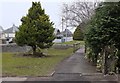
1
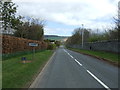
Entering Lauder
Looking north east on Stow Road.
Image: © JThomas
Taken: 20 Apr 2017
0.09 miles
2

Lauder from the air
Viewed from a Prague bound flight from Edinburgh.
Image: © Thomas Nugent
Taken: 3 Jul 2018
0.16 miles
3
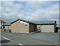
Lauder Bowling Club
On Stow road - founded 1888.
Image: © JThomas
Taken: 20 Apr 2017
0.17 miles
5
Brownsmuir Park, Lauder
Off Edinburgh Road.
Image: © JThomas
Taken: 20 Apr 2017
0.19 miles
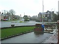
6
Washing Burn footbridge, Lauder
On the footpath alongside the A68 on the NW side of the town.
Image: © Jim Barton
Taken: 12 Apr 2013
0.19 miles
7
Lane behind Lauder Industrial Estate
A footpath that joins the A68 near the filling station.
Image: © Jim Barton
Taken: 19 Aug 2011
0.20 miles
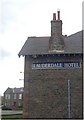
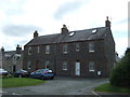
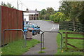
9
Rainy day in Lauder
The road junction outside the Lauderdale Hotel
Image: © Stanley Howe
Taken: 6 Apr 2006
0.20 miles
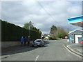
10
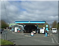
Service station on Edinburgh Road (A68), Lauder
Image: © JThomas
Taken: 20 Apr 2017
0.20 miles