IMAGES TAKEN NEAR TO
Mill Wynd, LAUDER, TD2 6SY
Introduction
This page details the photographs taken nearby to Mill Wynd, TD2 6SY by members of the Geograph project.
The Geograph project started in 2005 with the aim of publishing, organising and preserving representative images for every square kilometre of Great Britain, Ireland and the Isle of Man.

There are currently over 7.5m images from over14,400 individuals and you can help contribute to the project by visiting https://www.geograph.org.uk
Image Map
Images are licensed for reuse under creativecommons.org/licenses/by-sa/2.0
Notes
- Clicking on the map will re-center to the selected point.
- The higher the marker number, the further away the image location is from the centre of the postcode.
Image Listing (194 Images Found)
Images are licensed for reuse under creativecommons.org/licenses/by-sa/2.0
Image
Details
Distance
1

Lauder Town Hall
Looking towards the Town Hall, formerly the Tolbooth, which accommodated the local jail.
Image: © Mary and Angus Hogg
Taken: 2 May 2011
0.02 miles

3

Ordnance Survey Flush Bracket 10387
This can be found on the wall of Lauder Church.
For more detail see : http://www.bench-marks.org.uk/bm21931
Image: © Peter Wood
Taken: 16 Oct 2015
0.02 miles
4

OS Flush Bracket 10387 - Lauder, St Mary's Church
https://www.bench-marks.org.uk/bm21931
Image: © thejackrustles
Taken: 7 Oct 2023
0.03 miles
5
Location of OS Flush Bracket 10387 - Lauder, St Mary's Church
Image: © thejackrustles
Taken: 7 Oct 2023
0.03 miles


9

Lovely yew lined path Lauder, St Mary's Church
Image: © thejackrustles
Taken: 7 Oct 2023
0.03 miles
10

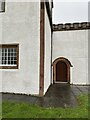
Lauder Old Parish Church
Viewed from the south-west.
Image: © Peter Wood
Taken: 16 Oct 2015
0.03 miles