IMAGES TAKEN NEAR TO
LAUDER, TD2 6SQ
Introduction
This page details the photographs taken nearby to TD2 6SQ by members of the Geograph project.
The Geograph project started in 2005 with the aim of publishing, organising and preserving representative images for every square kilometre of Great Britain, Ireland and the Isle of Man.

There are currently over 7.5m images from over14,400 individuals and you can help contribute to the project by visiting https://www.geograph.org.uk
Image Map
Images are licensed for reuse under creativecommons.org/licenses/by-sa/2.0
Notes
- Clicking on the map will re-center to the selected point.
- The higher the marker number, the further away the image location is from the centre of the postcode.
Image Listing (13 Images Found)
Images are licensed for reuse under creativecommons.org/licenses/by-sa/2.0
Image
Details
Distance
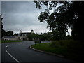
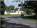
1
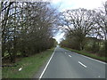
The junction of the A6089 with the A697 at Whiteburn
Looking northward from the A6089.
Image: © Peter Wood
Taken: 6 Oct 2016
0.08 miles
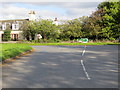
2
Junction of A697 and A6089 Roads
At Whiteburn in Berwickshire
Image: © James Denham
Taken: 27 Aug 2008
0.08 miles
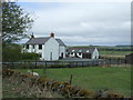
4
Whiteburn, at the junction of A697 and A6089
Image: © M J Richardson
Taken: 21 Sep 2008
0.09 miles
5
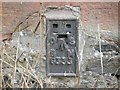
Ordnance Survey Flush Bracket G333
This can be found on the wall of a building at Whiteburn.
For more detail see : http://www.bench-marks.org.uk/bm20154
Image: © Peter Wood
Taken: 6 Oct 2016
0.09 miles
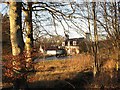
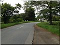
9
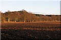
Hindside Hill
The western foot of Hindside Hill, taken from Whiteburn. The ploughed field is protected by a beech strip wood.
Image: © Richard Webb
Taken: 8 Dec 2006
0.16 miles