IMAGES TAKEN NEAR TO
TD2 6RR
Introduction
This page details the photographs taken nearby to TD2 6RR by members of the Geograph project.
The Geograph project started in 2005 with the aim of publishing, organising and preserving representative images for every square kilometre of Great Britain, Ireland and the Isle of Man.

There are currently over 7.5m images from over14,400 individuals and you can help contribute to the project by visiting https://www.geograph.org.uk
Image Map
Images are licensed for reuse under creativecommons.org/licenses/by-sa/2.0
Notes
- Clicking on the map will re-center to the selected point.
- The higher the marker number, the further away the image location is from the centre of the postcode.
Image Listing (9 Images Found)
Images are licensed for reuse under creativecommons.org/licenses/by-sa/2.0
Image
Details
Distance
1
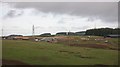
Construction site, Soutra
A lot of work has been undertaken here, out of sight of the A68 over the last year. A new substation has appeared along with ongoing work on buildings - seems very little for 12 months.
Image: © Richard Webb
Taken: 14 Oct 2008
0.01 miles
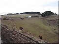
2
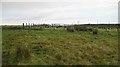
Sheep pens, Dun Law
Near the turbines, post and wire fenced sheep pens.
Image: © Richard Webb
Taken: 14 Oct 2008
0.19 miles
3
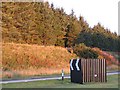
A 68
Big bend at the top of the climb out of Lauderdale. The cutting is a perfect trap for drifting snow, so the conifer strip is very useful as shelter.
Image: © Richard Webb
Taken: 5 Oct 2007
0.20 miles
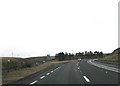
4
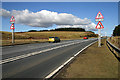
The A68 at Renshaw Rig
There is a crawler lane on this uphill section for vehicles travelling in the Edinburgh direction before the long straight between Dun Law and Carfrae Common.
Image: © Walter Baxter
Taken: 10 Mar 2009
0.20 miles
5
A filled cleugh
A steep reentrant has been filled by the realigned A68 on Soutra Hill. Previously the road had a bendy route down into Lauderdale, but now the road is straighter with the redundant bends being used as lay-bys.
Image: © Richard Webb
Taken: 26 Feb 2008
0.21 miles
7
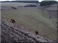
Cattle, Soutra
Steep slopes beneath the A68.
Image: © Richard Webb
Taken: 26 Feb 2008
0.22 miles
8
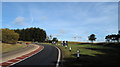
A68 rising to pass the Dun Law Wind Farm
The Dun Law Wind Farm occupies the moorland to the west and east of the A68 as it rises to its highest point at 363m just around the corner in the image. Several turbines of the wind farm can be seen too.
Image: © Trevor Littlewood
Taken: 31 Oct 2010
0.23 miles
9
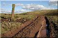
A track on Renshaw Rig
Access for farm vehicles to a large grazing field.
Image: © Walter Baxter
Taken: 10 Mar 2009
0.23 miles