IMAGES TAKEN NEAR TO
TD2 6AF
Introduction
This page details the photographs taken nearby to TD2 6AF by members of the Geograph project.
The Geograph project started in 2005 with the aim of publishing, organising and preserving representative images for every square kilometre of Great Britain, Ireland and the Isle of Man.

There are currently over 7.5m images from over14,400 individuals and you can help contribute to the project by visiting https://www.geograph.org.uk
Image Map
Images are licensed for reuse under creativecommons.org/licenses/by-sa/2.0
Notes
- Clicking on the map will re-center to the selected point.
- The higher the marker number, the further away the image location is from the centre of the postcode.
Image Listing (4 Images Found)
Images are licensed for reuse under creativecommons.org/licenses/by-sa/2.0
Image
Details
Distance
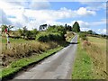
1
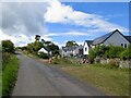
New houses above Oxton
On the road to Overhowden
Image: © Richard Webb
Taken: 19 Aug 2022
0.04 miles
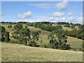
4
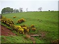
Clora Burn
Red sandstone shows in the colour of the mud. Cow pasture outside Oxton.
Image: © Richard Webb
Taken: 26 May 2006
0.22 miles