IMAGES TAKEN NEAR TO
TD15 2UT
Introduction
This page details the photographs taken nearby to TD15 2UT by members of the Geograph project.
The Geograph project started in 2005 with the aim of publishing, organising and preserving representative images for every square kilometre of Great Britain, Ireland and the Isle of Man.

There are currently over 7.5m images from over14,400 individuals and you can help contribute to the project by visiting https://www.geograph.org.uk
Image Map
Images are licensed for reuse under creativecommons.org/licenses/by-sa/2.0
Notes
- Clicking on the map will re-center to the selected point.
- The higher the marker number, the further away the image location is from the centre of the postcode.
Image Listing (40 Images Found)
Images are licensed for reuse under creativecommons.org/licenses/by-sa/2.0
Image
Details
Distance
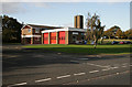
2
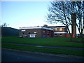
Berwick Fire Station
To the north side of Ord Drive (the A698).
Image: © Barbara Carr
Taken: 26 Sep 2013
0.10 miles
3
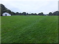
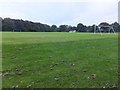
Public park, Tweedmouth
Looking by the swings to the football ground.
Image: © Barbara Carr
Taken: 30 Sep 2013
0.10 miles
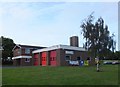
6
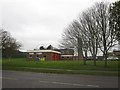
Berwick Fire Station
The fire station in Berwick upon Tweed.
Image: © Graham Robson
Taken: 3 May 2012
0.10 miles
7
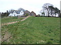
Mill Farm
Looking southward from the riverside path near Tweedmouth.
Image: © Barbara Carr
Taken: 13 Apr 2009
0.11 miles
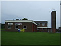
9
Berwick-upon-Tweed Fire Station
Situated on the northwest side of the A698 in Tweedside Industrial Estate.
Image: © Walter Baxter
Taken: 11 Oct 2009
0.12 miles
10
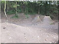
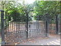
BMX park, Tweedmouth
Close by the fire-station, under the railway line.
Image: © Barbara Carr
Taken: 30 Sep 2013
0.12 miles