IMAGES TAKEN NEAR TO
The Croft, BERWICK-UPON-TWEED, TD15 2NB
Introduction
This page details the photographs taken nearby to The Croft, TD15 2NB by members of the Geograph project.
The Geograph project started in 2005 with the aim of publishing, organising and preserving representative images for every square kilometre of Great Britain, Ireland and the Isle of Man.

There are currently over 7.5m images from over14,400 individuals and you can help contribute to the project by visiting https://www.geograph.org.uk
Image Map (Loading...)


Getting Data...Please wait
Leaflet Map data © OpenStreetMap
Images are licensed for reuse under creativecommons.org/licenses/by-sa/2.0
Notes
- Clicking on the map will re-center to the selected point.
- The higher the marker number, the further away the image location is from the centre of the postcode.
Image Listing (38 Images Found)
Images are licensed for reuse under creativecommons.org/licenses/by-sa/2.0
Image
Details
Distance
1
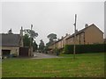
The Croft, East Ord
The Croft is a residential street leading off East Ord Village Green.
Image: © Graham Robson
Taken: 21 Jun 2012
0.03 miles
2
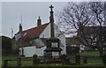
War Memorial East Ord
Standing at top (South) end of the village green. The top plaque lists three men who were killed in WW1, the other nine in WW2.
Image: © Stafford Little
Taken: 6 Jan 2006
0.06 miles
3
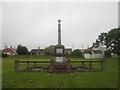
East Ord village war memorial
East Ord war memorial is located in a corner of the large village green.
Image: © Graham Robson
Taken: 21 Jun 2012
0.06 miles
4
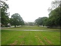
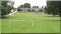
Football pitch on East Ord Village Green
This small football pitch is located on part of East Ord Village Green.
Image: © Graham Robson
Taken: 21 Jun 2012
0.08 miles
5
The Green, East Ord
Goalposts on a narrow strip of ground beside a road.
Image: © Richard Webb
Taken: 23 Aug 2010
0.10 miles
6
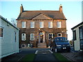
Ord House
Once the home of Lady Francis Osborne, this front facade was added to an earlier house in 1789. It is now the bar, restaurant and clubhouse of the Ord Caravan and Country Club. This caravan site has won many awards.
Image: © Stafford Little
Taken: 11 Jan 2006
0.10 miles
7
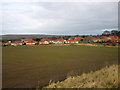
Looking across an arable field towards East Ord
Looking across an arable field towards East Ord. The houses in the foreground are part of East Ord Gardens, a relatively recently completed housing development.
Image: © Graham Robson
Taken: 20 Feb 2013
0.10 miles
8
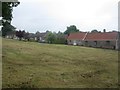
Houses facing onto East Ord Village Green
This row of bungalows nestle alongside the edge of East Ord Village Green.
Image: © Graham Robson
Taken: 21 Jun 2012
0.11 miles
9
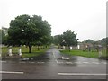
Road bisecting the village green, East Ord
This tree lined road bisects the village green. On the right side of the road are the village hall Image and a children's play park Image, both visible in this photograph. On the left side are a football pitch Image and the village war memorial Image
Image: © Graham Robson
Taken: 21 Jun 2012
0.11 miles
10
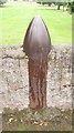
Shell in the wall
An unfeasibly large shell incorporated in a wall on East Ord Green, as you do.
Image: © Richard Webb
Taken: 23 Aug 2010
0.12 miles