IMAGES TAKEN NEAR TO
Billendean Terrace, BERWICK-UPON-TWEED, TD15 2DJ
Introduction
This page details the photographs taken nearby to Billendean Terrace, TD15 2DJ by members of the Geograph project.
The Geograph project started in 2005 with the aim of publishing, organising and preserving representative images for every square kilometre of Great Britain, Ireland and the Isle of Man.

There are currently over 7.5m images from over14,400 individuals and you can help contribute to the project by visiting https://www.geograph.org.uk
Image Map
Images are licensed for reuse under creativecommons.org/licenses/by-sa/2.0
Notes
- Clicking on the map will re-center to the selected point.
- The higher the marker number, the further away the image location is from the centre of the postcode.
Image Listing (106 Images Found)
Images are licensed for reuse under creativecommons.org/licenses/by-sa/2.0
Image
Details
Distance
1
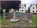
Memorial, Askew Crescent, Tweedmouth
A concrete bench with an attached plaque in the centre of the grassed area in front of the houese on Askew Crescent.
Image: © Graham Robson
Taken: 4 Jul 2022
0.02 miles
2
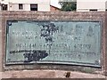
Commemorative plaque, Askew Crescent, Tweedmouth
This plaque, fixed to the bench in Image commemorates the gift of a row of houses to the borough in 1925. It reads:
1925
THE HOUSES ERECTED ON THIS SITE ARE
THE GIFT TO THE BOROUGH
OF
WILLIAM HAGGERSTON ASKEW
OF LADYKIRK
IN COMMEMORATION OF THE LONG ASSOCIATION OF HIS FAMILY WITH THE TOWN OF
BERWICK-UPON-TWEED
Image: © Graham Robson
Taken: 4 Jul 2022
0.02 miles
3
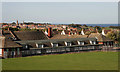
Tweedmouth County Middle School
Situated in Billendean Terrace, Spittal and viewed from Northumberland Road.
Image: © Walter Baxter
Taken: 26 Sep 2009
0.04 miles
4
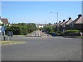
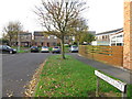
Billendean Terrace, Tweedmouth
Billendean Terrace, viewed from the roundabout at its junction with the A1167, Northumberland Road. The street is lined with typical 1930's semi detached houses and is a busy urban road linking Tweedmouth with Spittal.
Image: © Graham Robson
Taken: 14 Jun 2012
0.06 miles
6
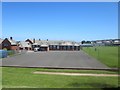
Tweedmouth Middle School
Tweedmouth Middle School seen from Northumberland road (the A1167). The school caters mainly for children from the Tweedmouth area between the ages of 8 and 13, or years 5 to 8.
Image: © Graham Robson
Taken: 14 Jun 2012
0.06 miles
7
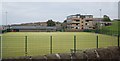
Berwick Community High School artificial pitch
Image: © N Chadwick
Taken: 1 Jun 2011
0.07 miles
8
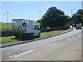
Preparing for the torch relay
It's probably not a coincidence that a crew of council litter pickers are in action on Northumberland Road (A1167) 4 hours before the olympic flame and its entourage pass by.
Image: © Graham Robson
Taken: 14 Jun 2012
0.07 miles
9
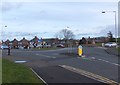
Roundabout on the A1167, Tweedmouth
Approaching the roundabout from the Farmfoods carpark.
Image: © Barbara Carr
Taken: 2 Feb 2013
0.07 miles
10
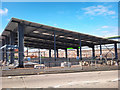
New Farmfoods store under construction
This new building, to be a Farmfoods store is located on the site of the former Bonarsteads pub, on Northumberland Road in Tweedmouth adjacent to the Tweedbank Retail Park and the Swan Centre for Leisure. The pub closed several years ago due to a lack of trade and had been unable to find a tenant, so it is making way for a new purpose built Farmfoods to replace their current arguably cramped town centre premises on Marygate. So far the site has been cleared, foundations laid, steel frame erected, roof added and floor laid.
Image: © Graham Robson
Taken: 14 Jul 2011
0.08 miles