IMAGES TAKEN NEAR TO
Cantys Terrace, BERWICK-UPON-TWEED, TD15 1SX
Introduction
This page details the photographs taken nearby to Cantys Terrace, TD15 1SX by members of the Geograph project.
The Geograph project started in 2005 with the aim of publishing, organising and preserving representative images for every square kilometre of Great Britain, Ireland and the Isle of Man.

There are currently over 7.5m images from over14,400 individuals and you can help contribute to the project by visiting https://www.geograph.org.uk
Image Map (Loading...)


Getting Data...Please wait
Leaflet Map data © OpenStreetMap
Images are licensed for reuse under creativecommons.org/licenses/by-sa/2.0
Notes
- Clicking on the map will re-center to the selected point.
- The higher the marker number, the further away the image location is from the centre of the postcode.
Image Listing (9 Images Found)
Images are licensed for reuse under creativecommons.org/licenses/by-sa/2.0
Image
Details
Distance
1
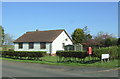
Bungalow on the B6461
Showing position of Postbox No. TD15 77.
See Image] for postbox.
Image: © JThomas
Taken: 20 Apr 2017
0.03 miles
2

Elizabeth II postbox on the B6461
Image: © JThomas
Taken: 20 Apr 2017
0.03 miles
3
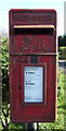
Close up, Elizabeth II postbox on the B6461
Postbox No. TD15 77.
See Image] for wider view.
Image: © JThomas
Taken: 20 Apr 2017
0.03 miles
5
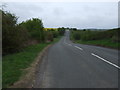
National Cycle Route 1
B6461 heading east towards Berwick.
Image: © JThomas
Taken: 8 May 2015
0.12 miles
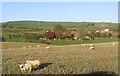
6
Low Baldersbury
Just across the Common Burn.
Image: © Russel Wills
Taken: 10 Aug 2018
0.17 miles
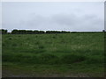
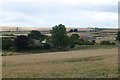
7
Grazing sheep
In a stubble field by the B6461. Grangeburn Mill Farm is to the right.
Image: © Walter Baxter
Taken: 11 Nov 2006
0.17 miles
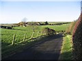
8
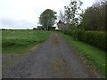
Bridleway near Grangeburn Mill Farm
Looking north.
Image: © JThomas
Taken: 8 May 2015
0.21 miles