IMAGES TAKEN NEAR TO
Magdalene Fields, BERWICK-UPON-TWEED, TD15 1NE
Introduction
This page details the photographs taken nearby to Magdalene Fields, TD15 1NE by members of the Geograph project.
The Geograph project started in 2005 with the aim of publishing, organising and preserving representative images for every square kilometre of Great Britain, Ireland and the Isle of Man.

There are currently over 7.5m images from over14,400 individuals and you can help contribute to the project by visiting https://www.geograph.org.uk
Image Map (Loading...)


Getting Data...Please wait
Leaflet Map data © OpenStreetMap
Images are licensed for reuse under creativecommons.org/licenses/by-sa/2.0
Notes
- Clicking on the map will re-center to the selected point.
- The higher the marker number, the further away the image location is from the centre of the postcode.
Image Listing (226 Images Found)
Images are licensed for reuse under creativecommons.org/licenses/by-sa/2.0
Image
Details
Distance
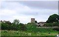
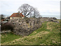
2
Lord's Mount
The remains of the bastion from Henry VIII's time. Originally of two stories, the upper storey was removed as early as the reign of Elizabeth when the new ramparts were built.
Image: © Alan Murray-Rust
Taken: 27 Dec 2009
0.02 miles
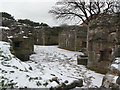
3
The Lord's Mount, interior
Built between 1539 and 1542 as a reinforcement to the existing town walls.
Image: © Jonathan Thacker
Taken: 22 May 2012
0.02 miles
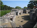
4
Old ramparts at Lord's Mount
The medieval ramparts were abandoned when the new defences were built in the reign of Queen Elizabeth. The Lord's Mount bastion had been built during the time of Henry VIII, and was largely dismantled at the same time.
Image: © Alan Murray-Rust
Taken: 27 Dec 2009
0.02 miles
5
Lords Mount, Berwick-upon-Tweed
Lords Mount, built during the reign of King Henry VIII as part of fortifications built around the town.
Image: © Graham Robson
Taken: 2 Apr 2013
0.02 miles
6
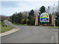
Main entrance to Berwick Holiday Park
The main vehicular access to Berwick Holiday Park. The site, owned by Bourne Leisure and trading under the Haven umbrella, is home to a large number of static caravans.
Image: © Graham Robson
Taken: 2 Apr 2013
0.04 miles
7
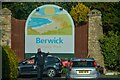
Berwick-Upon-Tweed : Northumberland Avenue
Heading down to the Berwick Holiday Park.
Image: © Lewis Clarke
Taken: 21 Sep 2020
0.04 miles
9
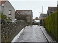
Lane off Low Greens
In better seasons this is the way on foot to the Berwick Holiday Centre. On this occasion it was potentially lethal - rain falling on compacted ice. I gave it a miss!
Image: © Alan Murray-Rust
Taken: 27 Dec 2009
0.06 miles
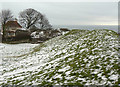
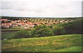
10
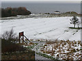
Magdalene Fields
The fact that this is a golf course is concealed by the covering of snow, but this does help to highlight the fact that this land, close under the town walls, was subject to ridge and furrow cultivation.
Image: © Alan Murray-Rust
Taken: 27 Dec 2009
0.07 miles