IMAGES TAKEN NEAR TO
EYEMOUTH, TD14 5UB
Introduction
This page details the photographs taken nearby to TD14 5UB by members of the Geograph project.
The Geograph project started in 2005 with the aim of publishing, organising and preserving representative images for every square kilometre of Great Britain, Ireland and the Isle of Man.

There are currently over 7.5m images from over14,400 individuals and you can help contribute to the project by visiting https://www.geograph.org.uk
Image Map
Images are licensed for reuse under creativecommons.org/licenses/by-sa/2.0
Notes
- Clicking on the map will re-center to the selected point.
- The higher the marker number, the further away the image location is from the centre of the postcode.
Image Listing (14 Images Found)
Images are licensed for reuse under creativecommons.org/licenses/by-sa/2.0
Image
Details
Distance
3
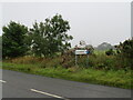
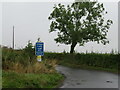
Roadsign for Lumsdaine
On the A1107 west of Coldingham.
Image: © M J Richardson
Taken: 8 Sep 2022
0.08 miles
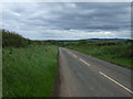
5
The road to Lumsdaine
A single track, cul de sac road, after 3km, that heads towards the coast.
Image: © M J Richardson
Taken: 8 Sep 2022
0.09 miles
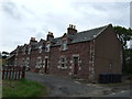
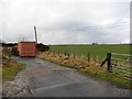
6
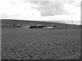
Bogangreen.
Farm seen across a newly cultivated field.
Image: © Richard Webb
Taken: 8 Apr 2006
0.09 miles
7
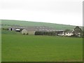
Looking towards the farm at Bogangreen
Looking across an arable field towards the farm steading at Bogangreen.
Image: © Graham Robson
Taken: 13 Jun 2015
0.11 miles
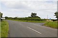
8
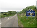
Entering Coldingham along the A1107
Entering Coldingham from the north west along the A1107.
Image: © Graham Robson
Taken: 13 Jun 2015
0.11 miles
9
Old road alignment
Now useful hard standing.
Image: © Richard Webb
Taken: 12 Feb 2011
0.12 miles
10
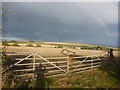
Berwickshire Landscape : Field Gateway Near Bogangreen, Coldingham
Image: © Richard West
Taken: 10 Oct 2014
0.12 miles