IMAGES TAKEN NEAR TO
EYEMOUTH, TD14 5TG
Introduction
This page details the photographs taken nearby to TD14 5TG by members of the Geograph project.
The Geograph project started in 2005 with the aim of publishing, organising and preserving representative images for every square kilometre of Great Britain, Ireland and the Isle of Man.

There are currently over 7.5m images from over14,400 individuals and you can help contribute to the project by visiting https://www.geograph.org.uk
Image Map (Loading...)


Getting Data...Please wait
Leaflet Map data © OpenStreetMap
Images are licensed for reuse under creativecommons.org/licenses/by-sa/2.0
Notes
- Clicking on the map will re-center to the selected point.
- The higher the marker number, the further away the image location is from the centre of the postcode.
Image Listing (12 Images Found)
Images are licensed for reuse under creativecommons.org/licenses/by-sa/2.0
Image
Details
Distance
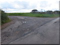
1
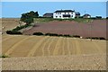
Field patterns at Highlaws farm
Various stages of cultivation in the S-facing fields below the farmhouse, seen from a nearby field track.
Image: © Jim Barton
Taken: 4 Sep 2012
0.00 miles
2
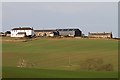
Highlaws Farm
The farm was viewed from the adjoining square to the south.
Image: © Walter Baxter
Taken: 19 Nov 2011
0.02 miles
4
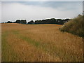
Ripening Crops
Looking NW from Highlaws Farm.
Image: © Lisa Jarvis
Taken: 29 Jul 2006
0.13 miles
6
Short track into farmland
To the northeast of Linthill.
Image: © Barbara Carr
Taken: 18 Sep 2013
0.23 miles
7
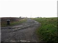
Road to Highlaws Farm
Looking along the rough road which leads to Highlaws Farm.
Image: © Graham Robson
Taken: 21 Jan 2014
0.23 miles
8
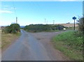
Minor road to Eyemouth
By the junction with the road to Highlaws Farm. Housing by the A1107 on the outskirts of Eyemouth can be seen to the left of photo, with a very blue North Sea in the distance.
Image: © Barbara Carr
Taken: 18 Sep 2013
0.24 miles
9
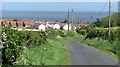
Descent into Eyemouth
A narrow road and route 76 of the National Cycle Network descends into Eyemouth.
Image: © Richard Webb
Taken: 19 May 2011
0.24 miles
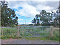
10
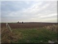
Gateway into ploughed arable field, near Highlaws Farm
A gateway providing access onto ploughed arable land near Highlaws Farm.
Image: © Graham Robson
Taken: 21 Jan 2014
0.24 miles