IMAGES TAKEN NEAR TO
Upper Burnmouth, Burnmouth, EYEMOUTH, TD14 5SN
Introduction
This page details the photographs taken nearby to TD14 5SN by members of the Geograph project.
The Geograph project started in 2005 with the aim of publishing, organising and preserving representative images for every square kilometre of Great Britain, Ireland and the Isle of Man.

There are currently over 7.5m images from over14,400 individuals and you can help contribute to the project by visiting https://www.geograph.org.uk
Image Map
Images are licensed for reuse under creativecommons.org/licenses/by-sa/2.0
Notes
- Clicking on the map will re-center to the selected point.
- The higher the marker number, the further away the image location is from the centre of the postcode.
Image Listing (162 Images Found)
Images are licensed for reuse under creativecommons.org/licenses/by-sa/2.0
Image
Details
Distance
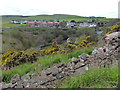
2
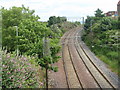
The East Coast Main Line railway
Runs through the middle of the village of Burnmouth.
The road on the left leads steeply to the harbour.
Image: © Russel Wills
Taken: 13 Aug 2021
0.03 miles
3
The East Coast Main Line
Looking southeast from the bridge over at Burnmouth.
Image: © M J Richardson
Taken: 2 Jul 2017
0.03 miles
4

A garden spider (Araneus diadematus)
The spider made its web in an ivy-clad wall at Burnmouth.
Image: © Walter Baxter
Taken: 17 Sep 2021
0.04 miles
5
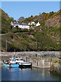
Burnmouth Brae From The Harbour
Rather a steep hill, and the location of an annual race.
Image: © James T M Towill
Taken: 20 Apr 2017
0.05 miles
6
Burnmouth viewed from the Berwickshire Coastal Path
Image: © Mat Fascione
Taken: 3 May 2018
0.05 miles
7
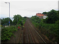
Looking south down the East Coast Mainline through Burnmouth
Looking south from the road bridge over the tracks in central Burnmouth along the line of the East Coast Mainline.
Image: © Graham Robson
Taken: 3 Jul 2013
0.05 miles
8
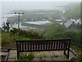
Coastal Berwickshire : A Bench With A View of Burnmouth Harbour
Walking down the narrow track to Partanhall one passes this neat, well placed bench, which commands an excellent view of Burnmouth harbour - even on a misty wet midsummer morning like this one.
On the return journey back up the hill it offered a welcome opportunity to catch breath, nosh some sarnies and guzzle some hot tea and caramel wafers. Hats off to those kindly and considerate souls who placed this fine facility here.
Image: © Richard West
Taken: 21 Jun 2011
0.06 miles
9
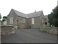
Former Burnmouth School
The former Burnmouth School building. The building ceased to be used as a school when it closed in June 2005. An article written at the time of the schools closure in the local newspaper is here: http://www.berwickshirenews.co.uk/news/local-headlines/school-doors-close-at-hutton-and-burnmouth-1-236955
Image: © Graham Robson
Taken: 3 Jul 2013
0.06 miles
10
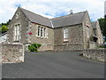
Burnmouth Primary School
Built in 1889, closed in 2005 and converted to residential use.
Image: © M J Richardson
Taken: 2 Jul 2017
0.06 miles