IMAGES TAKEN NEAR TO
EYEMOUTH, TD14 5SH
Introduction
This page details the photographs taken nearby to TD14 5SH by members of the Geograph project.
The Geograph project started in 2005 with the aim of publishing, organising and preserving representative images for every square kilometre of Great Britain, Ireland and the Isle of Man.

There are currently over 7.5m images from over14,400 individuals and you can help contribute to the project by visiting https://www.geograph.org.uk
Image Map
Images are licensed for reuse under creativecommons.org/licenses/by-sa/2.0
Notes
- Clicking on the map will re-center to the selected point.
- The higher the marker number, the further away the image location is from the centre of the postcode.
Image Listing (18 Images Found)
Images are licensed for reuse under creativecommons.org/licenses/by-sa/2.0
Image
Details
Distance
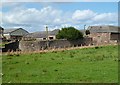
1
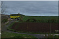
Fairnieside through the trees
A large farm by the ECML.
Image: © N Chadwick
Taken: 21 Feb 2011
0.03 miles
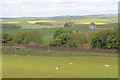
2
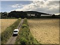
Farmland and country lane at Fairnieside
Image: © David Robinson
Taken: 24 Jul 2019
0.04 miles
5
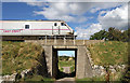
A railway bridge at Fairnieside
This bridge on the East Coast Line spans the road to Fairnieside Farm.
Image: © Walter Baxter
Taken: 19 Sep 2012
0.07 miles
6
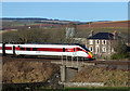
An LNER train passing Fairnieside Farm
This LNER Azuma train was heading south.
Image: © Walter Baxter
Taken: 18 Jan 2020
0.07 miles
7
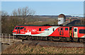
An LNER train passing Fairnieside Farm
The train is being hauled by Class 91 locomotive Durham Cathedral.
Image: © Walter Baxter
Taken: 18 Jan 2020
0.07 miles
8
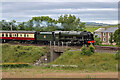
A steam special on the East Coast Main Line
46100 Royal Scot is passing Fairnieside Farm near Burnmouth.
Image: © Walter Baxter
Taken: 19 Jun 2022
0.08 miles
9
The East Coast Main Line at Fairnieside
Image: © Mick Garratt
Taken: 2 Jun 2010
0.09 miles