IMAGES TAKEN NEAR TO
EYEMOUTH, TD14 5LW
Introduction
This page details the photographs taken nearby to TD14 5LW by members of the Geograph project.
The Geograph project started in 2005 with the aim of publishing, organising and preserving representative images for every square kilometre of Great Britain, Ireland and the Isle of Man.

There are currently over 7.5m images from over14,400 individuals and you can help contribute to the project by visiting https://www.geograph.org.uk
Image Map
Images are licensed for reuse under creativecommons.org/licenses/by-sa/2.0
Notes
- Clicking on the map will re-center to the selected point.
- The higher the marker number, the further away the image location is from the centre of the postcode.
Image Listing (6 Images Found)
Images are licensed for reuse under creativecommons.org/licenses/by-sa/2.0
Image
Details
Distance
2
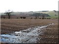
Return of a watercourse
Running water down a drainage line in stubble field at Horseley.
Image: © Richard Webb
Taken: 12 Feb 2011
0.07 miles
3
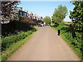
Horseley
Row of cottages by the farm at Horseley.
Image: © Richard Webb
Taken: 28 May 2006
0.10 miles
4
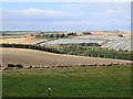
Sheep pasture, Horseley
Lammermuir Hills above the Eye Water.
Image: © Richard Webb
Taken: 16 Sep 2013
0.14 miles
5
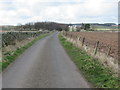
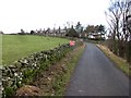
Road to Horseley in the Scottish Borders
Image: © ian shiell
Taken: 20 Mar 2020
0.24 miles
6
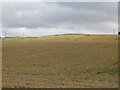
Barley, Horseley
A late cereal crop in the Lammermuir Hills.
Image: © Richard Webb
Taken: 16 Sep 2013
0.24 miles