IMAGES TAKEN NEAR TO
EYEMOUTH, TD14 5LT
Introduction
This page details the photographs taken nearby to TD14 5LT by members of the Geograph project.
The Geograph project started in 2005 with the aim of publishing, organising and preserving representative images for every square kilometre of Great Britain, Ireland and the Isle of Man.

There are currently over 7.5m images from over14,400 individuals and you can help contribute to the project by visiting https://www.geograph.org.uk
Image Map
Images are licensed for reuse under creativecommons.org/licenses/by-sa/2.0
Notes
- Clicking on the map will re-center to the selected point.
- The higher the marker number, the further away the image location is from the centre of the postcode.
Image Listing (13 Images Found)
Images are licensed for reuse under creativecommons.org/licenses/by-sa/2.0
Image
Details
Distance

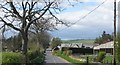
2
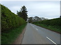
B6437 near Auchencrow Mains
Heading south east towards Chirnside.
Image: © JThomas
Taken: 8 May 2015
0.07 miles
4
Sprouts, Auchencrow
Taken on a mild day and sudden thaw.
Image: © Richard Webb
Taken: 19 Dec 2022
0.18 miles
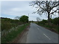
5
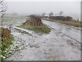
B6437, Auchencrow
During a thaw. Litter in the layby was provided by Greggs.
Image: © Richard Webb
Taken: 19 Dec 2022
0.18 miles
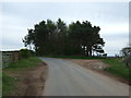
7
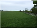
Farmland near Auchencrow Mains
Beside a disused railway off the B6437.
Image: © JThomas
Taken: 8 May 2015
0.22 miles
9
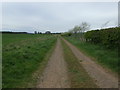
Farm track near Auchencrow Mains
Looking west.
Image: © JThomas
Taken: 8 May 2015
0.23 miles
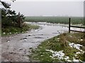
10
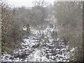
Berwickshire Railway trackbed
Winter vegetation and thawing snow reveal a path.
Image: © Richard Webb
Taken: 19 Dec 2022
0.23 miles