IMAGES TAKEN NEAR TO
Albert Road, EYEMOUTH, TD14 5DE
Introduction
This page details the photographs taken nearby to Albert Road, TD14 5DE by members of the Geograph project.
The Geograph project started in 2005 with the aim of publishing, organising and preserving representative images for every square kilometre of Great Britain, Ireland and the Isle of Man.

There are currently over 7.5m images from over14,400 individuals and you can help contribute to the project by visiting https://www.geograph.org.uk
Image Map
Images are licensed for reuse under creativecommons.org/licenses/by-sa/2.0
Notes
- Clicking on the map will re-center to the selected point.
- The higher the marker number, the further away the image location is from the centre of the postcode.
Image Listing (618 Images Found)
Images are licensed for reuse under creativecommons.org/licenses/by-sa/2.0
Image
Details
Distance
1
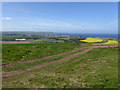
A prospect of Eyemouth
Seen from the Berwickshire Coast Path on Blaikie Heugh. The curved belt between the two fields of yellow oilseed rape is the new Harbour Road.
Image: © Oliver Dixon
Taken: 23 May 2015
0.01 miles
2
Eyemouth Day Hospital
The day hospital in Houndlaw Park was officially opened on 28th September 1995 and is linked in with the adjacent health centre. Patients may be seen and treated by a range of specialist staff including doctors, nurses, physiotherapists, occupational therapists, speech therapists, podiatrists and dieticians.
Image: © Walter Baxter
Taken: 29 Aug 2008
0.01 miles
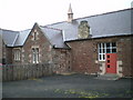
3
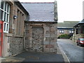
The Boys' entrance
Clearly legible above the disused doorway, carved into the stone.
Image: © Richard Law
Taken: 31 Jul 2008
0.01 miles
4
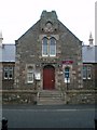
The Girls' entrance
The legend above the door says "Girls", as the designated entrance when the school was in use.
The stone plaque at the top of the gable tells us that this was a Public School, erected in 1878.
Image: © Richard Law
Taken: 31 Jul 2008
0.02 miles
5
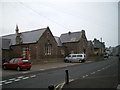
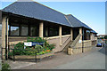
General view of Eyemouth Community Centre
Clearly a former school, probably of the Victorian era. It's now in use as the town Community Centre.
The clarity and quality of the picture was not helped by the persistent rain that started quarter of an hour before we arrived here.
Image: © Richard Law
Taken: 31 Jul 2008
0.02 miles
6
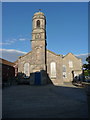
The Auld Kirk, Eyemouth
http://www.geograph.org.uk/photo/2157353
Image: © Alexander P Kapp
Taken: 14 Jun 2010
0.02 miles
7
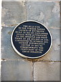
The Auld Kirk, Eyemouth, Plaque
http://www.geograph.org.uk/photo/2157352
Image: © Alexander P Kapp
Taken: 14 Jun 2010
0.02 miles
8
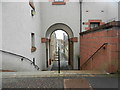
Reston Terrace in Eyemouth
Like so many old fishing ports, Eyemouth is full of atmospheric wynds and lanes leading to and from the vicinity of the harbour. Though Reston Terrace had been largely renewed, the atmospheric nature will never change. The archway leads from Albert Road, down steps passing the old town hall on the way to Church Street where the old town council house and Eyemouth Museum await.
Image: © James Denham
Taken: 26 Apr 2016
0.02 miles
9
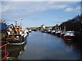
Eyemouth Harbour
Fishing Boats lined up along the river Eye in this busy harbour. In the distance you can see Gunsgreen House, an 18th century Merchants Villa designed by James Adam around 1855
Image: © Kevin Rae
Taken: 16 Feb 2006
0.03 miles
10
The Infants' entrance
The lintel above the bricked-up doorway says "Infants", as this must have been the designated entrance when the school was in use. There are two other pictures here, of the "Boys" and "Girls" entrances too.
Image: © Richard Law
Taken: 31 Jul 2008
0.03 miles