IMAGES TAKEN NEAR TO
GALASHIELS, TD1 3PW
Introduction
This page details the photographs taken nearby to TD1 3PW by members of the Geograph project.
The Geograph project started in 2005 with the aim of publishing, organising and preserving representative images for every square kilometre of Great Britain, Ireland and the Isle of Man.

There are currently over 7.5m images from over14,400 individuals and you can help contribute to the project by visiting https://www.geograph.org.uk
Image Map
Images are licensed for reuse under creativecommons.org/licenses/by-sa/2.0
Notes
- Clicking on the map will re-center to the selected point.
- The higher the marker number, the further away the image location is from the centre of the postcode.
Image Listing (48 Images Found)
Images are licensed for reuse under creativecommons.org/licenses/by-sa/2.0
Image
Details
Distance
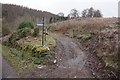
2
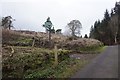
Southern Upland Way towards Howlands Plantation
Image: © Ian S
Taken: 5 Jan 2020
0.03 miles
3
Southern Upland Way towards Howlands Plantation
Image: © Ian S
Taken: 5 Jan 2020
0.03 miles
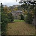
4
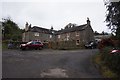
A quiet corner near Yair
Estate houses on the private road to Yair.
Image: © Jim Barton
Taken: 12 Jun 2011
0.04 miles
6
Southern Upland Way towards Howlands Plantation
Image: © Ian S
Taken: 5 Jan 2020
0.04 miles
7
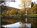
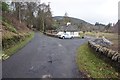
Yair
The River Tweed passing Yair House.
Image: © Richard Webb
Taken: 30 Oct 2007
0.06 miles
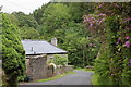
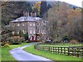
8
Yair House
Built in 1788.
Source: ‘Yair House | Canmore’. 2022. Canmore.org.uk [accessed 1 November 2022]
Image: © Mick Garratt
Taken: 31 Oct 2022
0.06 miles
9
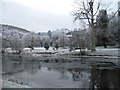
Yair
After many days of frost with the Tweed beginning to freeze over.
Image: © Richard Webb
Taken: 22 Dec 2007
0.07 miles
10
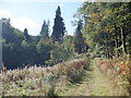
Path, Yair
Used by the Southern Upland Way, well surfaced and very scenic.
Image: © Richard Webb
Taken: 25 Sep 2024
0.10 miles