IMAGES TAKEN NEAR TO
Clovenfords, GALASHIELS, TD1 3LW
Introduction
This page details the photographs taken nearby to TD1 3LW by members of the Geograph project.
The Geograph project started in 2005 with the aim of publishing, organising and preserving representative images for every square kilometre of Great Britain, Ireland and the Isle of Man.

There are currently over 7.5m images from over14,400 individuals and you can help contribute to the project by visiting https://www.geograph.org.uk
Image Map
Images are licensed for reuse under creativecommons.org/licenses/by-sa/2.0
Notes
- Clicking on the map will re-center to the selected point.
- The higher the marker number, the further away the image location is from the centre of the postcode.
Image Listing (6 Images Found)
Images are licensed for reuse under creativecommons.org/licenses/by-sa/2.0
Image
Details
Distance
1
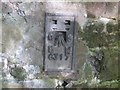
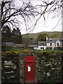
Ordnance Survey Flush Bracket G317
This can be found on the wall of a building at The Nest.
For more detail see : http://www.bench-marks.org.uk/bm17567
Image: © Peter Wood
Taken: 14 Oct 2015
0.03 miles
2
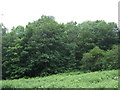
A drystane dyke separates two fields near the Nest
On the left bank of the River Tweed opposite Ashiestiel and Peel.
(Drystane Dyke means a dry stone wall)
Image: © James Denham
Taken: 17 Mar 2013
0.05 miles
3
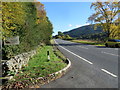
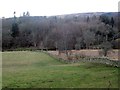
Road (A72) at The Nest
Looking south-eastward.
Image: © Peter Wood
Taken: 14 Oct 2015
0.09 miles
4
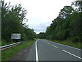
Peebles 13 Miles
Looking north west on the A72.
Image: © JThomas
Taken: 6 Jul 2017
0.20 miles