IMAGES TAKEN NEAR TO
Lairburn Drive, GALASHIELS, TD1 3AJ
Introduction
This page details the photographs taken nearby to Lairburn Drive, TD1 3AJ by members of the Geograph project.
The Geograph project started in 2005 with the aim of publishing, organising and preserving representative images for every square kilometre of Great Britain, Ireland and the Isle of Man.

There are currently over 7.5m images from over14,400 individuals and you can help contribute to the project by visiting https://www.geograph.org.uk
Image Map
Images are licensed for reuse under creativecommons.org/licenses/by-sa/2.0
Notes
- Clicking on the map will re-center to the selected point.
- The higher the marker number, the further away the image location is from the centre of the postcode.
Image Listing (64 Images Found)
Images are licensed for reuse under creativecommons.org/licenses/by-sa/2.0
Image
Details
Distance
1
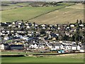
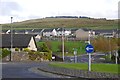
Clovenfords
The village is growing and at last is getting a school built to replace the old one down at Caddonfoot which other than being too small is a road safety nightmare. The new school is accompanied by some new housing. At this time there was a village shop and filling station as well as a pub still open here.
Image: © Richard Webb
Taken: 22 Jan 2012
0.01 miles
2
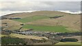
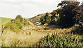
Caddonfoot and Meigle Hill
View from Laidlawstiel Hill.
Image: © Richard Webb
Taken: 3 Feb 2022
0.02 miles
3
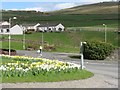
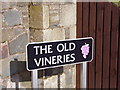
The Old Vineries
A view from the roundabout across to newish housing and the slopes of Meigle Hill.
Image: © M J Richardson
Taken: 17 Apr 2010
0.06 miles
4
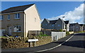
Todburn Way
One of the new housing developments at Clovenfords.
Image: © Mary and Angus Hogg
Taken: 25 Sep 2015
0.07 miles
5
Clovenfords
New houses on the south side of the village. There is also a new school here, replacing the poorly sited older school down by the Tweed.
2010 view Image
Image: © Richard Webb
Taken: 31 Oct 2015
0.09 miles
6
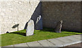
Stones at Clovenfords
These three stones have been placed beside Lairburn Drive in one of the new housing areas at Clovenfords.
Image: © Mary and Angus Hogg
Taken: 25 Sep 2015
0.09 miles
7
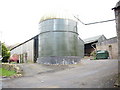
Meigle Farm, Clovenfords.
Sits off the A72.
Image: © James Denham
Taken: 13 Oct 2008
0.09 miles
8
Site of Clovenfords station
View NE, towards Galashiels: ex-NBR Edinburgh - Peebles - Galashiels line; the line and station were closed from 5/2/62 and nothing was to be seen in 1988. To the right is Meigle Hill (1,388 ft.).
Image: © Ben Brooksbank
Taken: 21 Aug 1988
0.09 miles
9
Clovenfords
The Old Vineries is a street in the village where once a thriving vineyard stood
Image: © James Denham
Taken: 24 Mar 2008
0.10 miles
10
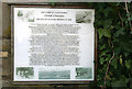
"The Glory of Clovenfords"
This information board at the entrance to the housing scheme at The Old Vineries in Clovenfords is titled:-
“THE GLORY OF CLOVENFORDS”
TWEED VINEYARDS
CREATED BY WILLIAM THOMSON IN 1869
The text on "The glory of Clovenfords" information board (made by Scottish Borders Council) was compiled by Mr Tom Quayle who commissioned the board when he was Chairman of the Clovenfords Community Council. Mr Quayle and two other members of the Community Council erected the board on site.
Tweed Vineries became famous and supplied Harrods of London and other large towns with quality grapes. The vineries closed in 1959 and the site is now occupied by housing.
Image: © Walter Baxter
Taken: 25 Apr 2009
0.11 miles