IMAGES TAKEN NEAR TO
COCKBURNSPATH, TD13 5XB
Introduction
This page details the photographs taken nearby to TD13 5XB by members of the Geograph project.
The Geograph project started in 2005 with the aim of publishing, organising and preserving representative images for every square kilometre of Great Britain, Ireland and the Isle of Man.

There are currently over 7.5m images from over14,400 individuals and you can help contribute to the project by visiting https://www.geograph.org.uk
Image Map
Images are licensed for reuse under creativecommons.org/licenses/by-sa/2.0
Notes
- Clicking on the map will re-center to the selected point.
- The higher the marker number, the further away the image location is from the centre of the postcode.
Image Listing (29 Images Found)
Images are licensed for reuse under creativecommons.org/licenses/by-sa/2.0
Image
Details
Distance
1
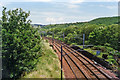
Cockburnspath station (site/remains), East Coast Main Line
View SE, towards Berwick-on-Tweed and the South: ex-North British section of the ECML. The station was closed to passengers 18/6/51, to goods 25/1/65.
Image: © Ben Brooksbank
Taken: 6 Jul 1997
0.01 miles
2
Cockburnspath station (remains), 1988
View northward, towards Edinburgh: ex-NBR ECML, Berwick-upon-Tweed - Edinburgh section. To relieve the path of the ECML expresses, the station was closed to passengers from 18/6/51, but not for goods until 25/1/65. The prominent landmark of Torness Nuclear Power Station is in the distance, beside the Firth of Forth: this had just been commissioned (5/88), after years of delay due to local opposition.
Image: © Ben Brooksbank
Taken: 22 Jun 1988
0.01 miles
3
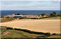
Pathhead Farm
Viewed from the northeast side of Eildbalks Wood from just outside the square.
Image: © Walter Baxter
Taken: 11 Sep 2010
0.03 miles
4
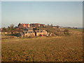
Winter morning light near Pathhead.
Taken from a train about to bear south, away from the coast, through Pease Dean.
Image: © Stanley Howe
Taken: 30 Dec 2006
0.03 miles
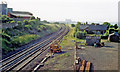
5

The East Coast Main Line at Cockburnspath
Torness power station is in the background.
Image: © Walter Baxter
Taken: 27 Feb 2022
0.04 miles
6
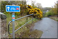
National Cycle Route 76 at Cockburnspath
National Cycle Route 76 is also known as the Round the Forth cycle route. It runs from Berwick-upon-Tweed to St Andrews.
Image: © Mat Fascione
Taken: 2 May 2018
0.09 miles
8
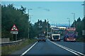
Cockburnspath : A1
Looking north on the A1 through the Scottish Borders region.
Image: © Lewis Clarke
Taken: 23 Sep 2020
0.10 miles
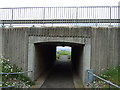
9
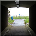
National Cycle Route 76 under the A1 at Cockburnspath
National Cycle Route 76 is also known as the Round the Forth cycle route. It runs from Berwick-upon-Tweed to St Andrews.
Image: © Mat Fascione
Taken: 2 May 2018
0.10 miles